You are here: Home > Network List > TA - USArray Transportable Network (new EarthScope stations) Stations List
> Station B18K Kokolik River, AK, USA > Earthquake Result Viewer
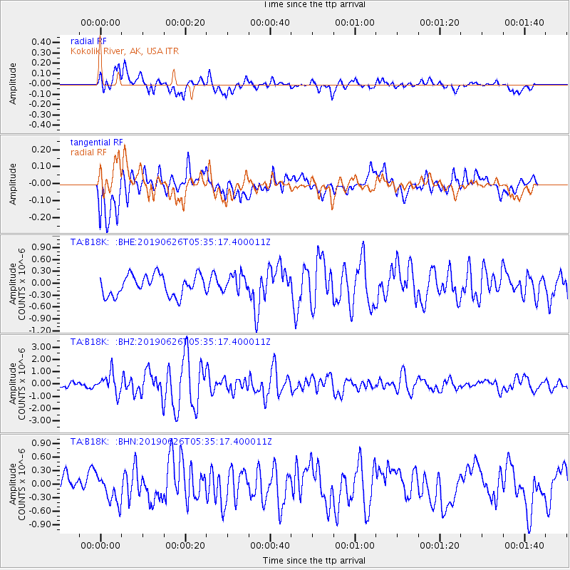
B18K Kokolik River, AK, USA - Earthquake Result Viewer
*The percent match for this event was below the threshold and hence no stack was calculated.
| Earthquake location: |
Panama-Costa Rica Border Region |
| Earthquake latitude/longitude: |
8.4/-82.8 |
| Earthquake time(UTC): |
2019/06/26 (177) 05:23:48 GMT |
| Earthquake Depth: |
10 km |
| Earthquake Magnitude: |
6.3 Mww |
| Earthquake Catalog/Contributor: |
NEIC PDE/us |
|
| Network: |
TA USArray Transportable Network (new EarthScope stations) |
| Station: |
B18K Kokolik River, AK, USA |
| Lat/Lon: |
69.36 N/161.80 W |
| Elevation: |
222 m |
|
| Distance: |
78.3 deg |
| Az: |
339.181 deg |
| Baz: |
97.312 deg |
| Ray Param: |
$rayparam |
*The percent match for this event was below the threshold and hence was not used in the summary stack. |
|
| Radial Match: |
75.10818 % |
| Radial Bump: |
400 |
| Transverse Match: |
76.29547 % |
| Transverse Bump: |
400 |
| SOD ConfigId: |
18369291 |
| Insert Time: |
2019-07-10 05:34:54.097 +0000 |
| GWidth: |
2.5 |
| Max Bumps: |
400 |
| Tol: |
0.001 |
|
Signal To Noise
| Channel | StoN | STA | LTA |
| TA:B18K: :BHZ:20190626T05:35:17.400011Z | 3.4061787 | 8.413041E-7 | 2.4699352E-7 |
| TA:B18K: :BHN:20190626T05:35:17.400011Z | 1.0408996 | 3.138236E-7 | 3.0149266E-7 |
| TA:B18K: :BHE:20190626T05:35:17.400011Z | 0.861026 | 2.2132478E-7 | 2.5704773E-7 |
| Arrivals |
| Ps | |
| PpPs | |
| PsPs/PpSs | |


