You are here: Home > Network List > IU - Global Seismograph Network (GSN - IRIS/USGS) Stations List
> Station PMG Port Moresby, New Guinea > Earthquake Result Viewer
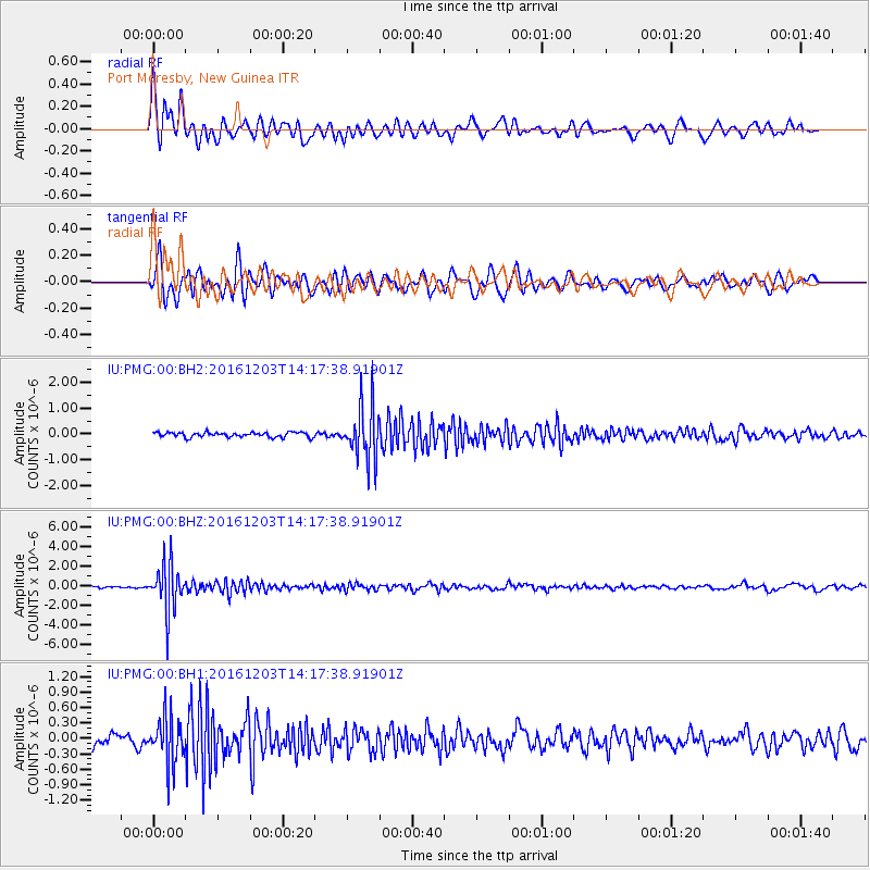
PMG Port Moresby, New Guinea - Earthquake Result Viewer
*The percent match for this event was below the threshold and hence no stack was calculated.
| Earthquake location: |
South Of Fiji Islands |
| Earthquake latitude/longitude: |
-22.6/-176.0 |
| Earthquake time(UTC): |
2016/12/03 (338) 14:11:09 GMT |
| Earthquake Depth: |
153 km |
| Earthquake Magnitude: |
5.5 mb |
| Earthquake Catalog/Contributor: |
NEIC PDE/us |
|
| Network: |
IU Global Seismograph Network (GSN - IRIS/USGS) |
| Station: |
PMG Port Moresby, New Guinea |
| Lat/Lon: |
9.40 S/147.16 E |
| Elevation: |
90 m |
|
| Distance: |
37.6 deg |
| Az: |
284.379 deg |
| Baz: |
114.862 deg |
| Ray Param: |
$rayparam |
*The percent match for this event was below the threshold and hence was not used in the summary stack. |
|
| Radial Match: |
81.22352 % |
| Radial Bump: |
400 |
| Transverse Match: |
78.54198 % |
| Transverse Bump: |
400 |
| SOD ConfigId: |
1894071 |
| Insert Time: |
2016-12-17 14:14:51.240 +0000 |
| GWidth: |
2.5 |
| Max Bumps: |
400 |
| Tol: |
0.001 |
|
Signal To Noise
| Channel | StoN | STA | LTA |
| IU:PMG:00:BHZ:20161203T14:17:38.91901Z | 25.480236 | 2.3833682E-6 | 9.353791E-8 |
| IU:PMG:00:BH1:20161203T14:17:38.91901Z | 4.948502 | 4.4940433E-7 | 9.081623E-8 |
| IU:PMG:00:BH2:20161203T14:17:38.91901Z | 11.36185 | 1.0765665E-6 | 9.475275E-8 |
| Arrivals |
| Ps | |
| PpPs | |
| PsPs/PpSs | |


