You are here: Home > Network List > TA - USArray Transportable Network (new EarthScope stations) Stations List
> Station J16K Anvik River, AK, USA > Earthquake Result Viewer
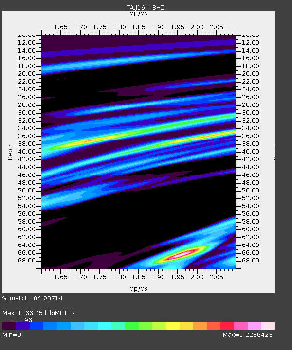
J16K Anvik River, AK, USA - Earthquake Result Viewer
| Earthquake location: |
Panama-Costa Rica Border Region |
| Earthquake latitude/longitude: |
8.4/-82.8 |
| Earthquake time(UTC): |
2019/06/26 (177) 05:23:48 GMT |
| Earthquake Depth: |
10 km |
| Earthquake Magnitude: |
6.3 Mww |
| Earthquake Catalog/Contributor: |
NEIC PDE/us |
|
| Network: |
TA USArray Transportable Network (new EarthScope stations) |
| Station: |
J16K Anvik River, AK, USA |
| Lat/Lon: |
63.28 N/160.60 W |
| Elevation: |
328 m |
|
| Distance: |
77.0 deg |
| Az: |
333.041 deg |
| Baz: |
97.098 deg |
| Ray Param: |
0.050593607 |
| Estimated Moho Depth: |
66.25 km |
| Estimated Crust Vp/Vs: |
1.96 |
| Assumed Crust Vp: |
6.276 km/s |
| Estimated Crust Vs: |
3.202 km/s |
| Estimated Crust Poisson's Ratio: |
0.32 |
|
| Radial Match: |
84.03714 % |
| Radial Bump: |
400 |
| Transverse Match: |
70.121796 % |
| Transverse Bump: |
400 |
| SOD ConfigId: |
18369291 |
| Insert Time: |
2019-07-10 05:35:47.971 +0000 |
| GWidth: |
2.5 |
| Max Bumps: |
400 |
| Tol: |
0.001 |
|

Signal To Noise
| Channel | StoN | STA | LTA |
| TA:J16K: :BHZ:20190626T05:35:10.449999Z | 3.7015011 | 6.214781E-7 | 1.6789893E-7 |
| TA:J16K: :BHN:20190626T05:35:10.449999Z | 1.085809 | 1.6667991E-7 | 1.5350757E-7 |
| TA:J16K: :BHE:20190626T05:35:10.449999Z | 3.0851452 | 4.4522983E-7 | 1.4431406E-7 |
| Arrivals |
| Ps | 10 SECOND |
| PpPs | 30 SECOND |
| PsPs/PpSs | 41 SECOND |


