You are here: Home > Network List > TA - USArray Transportable Network (new EarthScope stations) Stations List
> Station O17K Koliganek, Bristol Bay, AK, USA > Earthquake Result Viewer
O17K Koliganek, Bristol Bay, AK, USA - Earthquake Result Viewer
| Earthquake location: |
Panama-Costa Rica Border Region |
| Earthquake latitude/longitude: |
8.4/-82.8 |
| Earthquake time(UTC): |
2019/06/26 (177) 05:23:48 GMT |
| Earthquake Depth: |
10 km |
| Earthquake Magnitude: |
6.3 Mww |
| Earthquake Catalog/Contributor: |
NEIC PDE/us |
|
| Network: |
TA USArray Transportable Network (new EarthScope stations) |
| Station: |
O17K Koliganek, Bristol Bay, AK, USA |
| Lat/Lon: |
59.77 N/157.09 W |
| Elevation: |
156 m |
|
| Distance: |
74.9 deg |
| Az: |
329.696 deg |
| Baz: |
99.365 deg |
| Ray Param: |
0.052045356 |
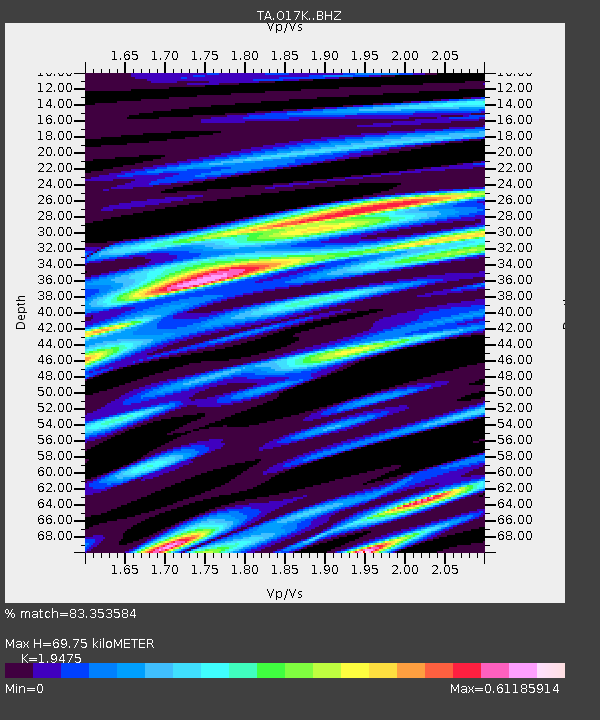
| Estimated Moho Depth: |
69.75 km |
| Estimated Crust Vp/Vs: |
1.95 |
| Assumed Crust Vp: |
6.276 km/s |
| Estimated Crust Vs: |
3.222 km/s |
| Estimated Crust Poisson's Ratio: |
0.32 |
|
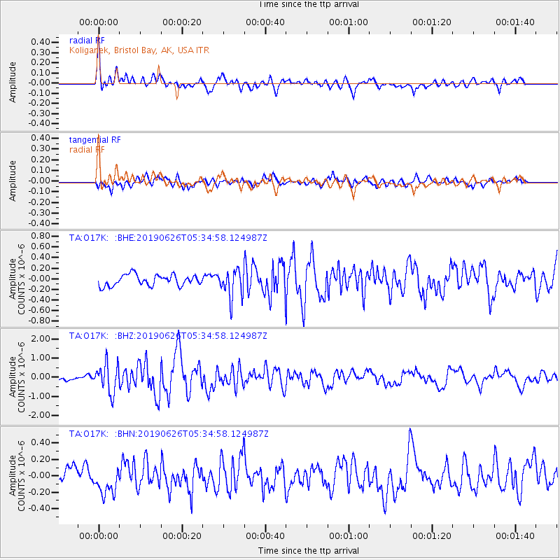
| Radial Match: |
83.353584 % |
| Radial Bump: |
400 |
| Transverse Match: |
66.740364 % |
| Transverse Bump: |
357 |
| SOD ConfigId: |
18369291 |
| Insert Time: |
2019-07-10 05:36:17.434 +0000 |
| GWidth: |
2.5 |
| Max Bumps: |
400 |
| Tol: |
0.001 |
|
Signal To Noise
| Channel | StoN | STA | LTA |
| TA:O17K: :BHZ:20190626T05:34:58.124987Z | 4.875462 | 7.659402E-7 | 1.5710104E-7 |
| TA:O17K: :BHN:20190626T05:34:58.124987Z | 1.9371761 | 1.7254634E-7 | 8.9071065E-8 |
| TA:O17K: :BHE:20190626T05:34:58.124987Z | 2.6175408 | 2.6984551E-7 | 1.0309123E-7 |
| Arrivals |
| Ps | 11 SECOND |
| PpPs | 32 SECOND |
| PsPs/PpSs | 43 SECOND |


