You are here: Home > Network List > WY - Yellowstone Wyoming Seismic Network Stations List
> Station YHH Holmes Hill, YNP, WY, USA > Earthquake Result Viewer
YHH Holmes Hill, YNP, WY, USA - Earthquake Result Viewer
| Earthquake location: |
Panama-Costa Rica Border Region |
| Earthquake latitude/longitude: |
8.4/-82.8 |
| Earthquake time(UTC): |
2019/06/26 (177) 05:23:48 GMT |
| Earthquake Depth: |
10 km |
| Earthquake Magnitude: |
6.3 Mww |
| Earthquake Catalog/Contributor: |
NEIC PDE/us |
|
| Network: |
WY Yellowstone Wyoming Seismic Network |
| Station: |
YHH Holmes Hill, YNP, WY, USA |
| Lat/Lon: |
44.79 N/110.85 W |
| Elevation: |
2717 m |
|
| Distance: |
43.6 deg |
| Az: |
330.948 deg |
| Baz: |
137.571 deg |
| Ray Param: |
0.0724358 |
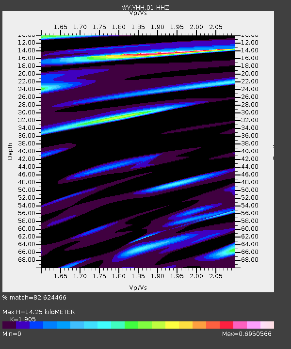
| Estimated Moho Depth: |
14.25 km |
| Estimated Crust Vp/Vs: |
1.90 |
| Assumed Crust Vp: |
6.35 km/s |
| Estimated Crust Vs: |
3.333 km/s |
| Estimated Crust Poisson's Ratio: |
0.31 |
|
| Radial Match: |
82.624466 % |
| Radial Bump: |
332 |
| Transverse Match: |
60.381367 % |
| Transverse Bump: |
400 |
| SOD ConfigId: |
18369291 |
| Insert Time: |
2019-07-10 05:38:51.299 +0000 |
| GWidth: |
2.5 |
| Max Bumps: |
400 |
| Tol: |
0.001 |
|
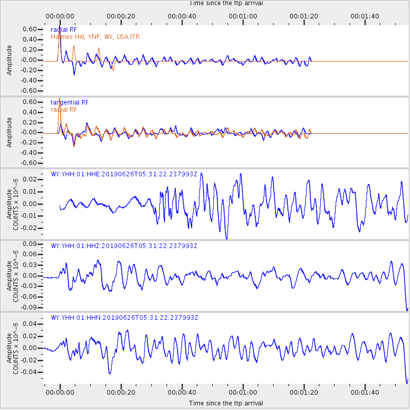
Signal To Noise
| Channel | StoN | STA | LTA |
| WY:YHH:01:HHZ:20190626T05:31:22.237993Z | 5.478256 | 2.155183E-8 | 3.9340677E-9 |
| WY:YHH:01:HHN:20190626T05:31:22.237993Z | 4.21294 | 9.67969E-9 | 2.2976092E-9 |
| WY:YHH:01:HHE:20190626T05:31:22.237993Z | 2.6913748 | 7.983539E-9 | 2.9663425E-9 |
| Arrivals |
| Ps | 2.2 SECOND |
| PpPs | 6.1 SECOND |
| PsPs/PpSs | 8.3 SECOND |


