You are here: Home > Network List > TA - USArray Transportable Network (new EarthScope stations) Stations List
> Station C21A Desert Coulee Ranch, Glasgow, MT, USA > Earthquake Result Viewer
C21A Desert Coulee Ranch, Glasgow, MT, USA - Earthquake Result Viewer

| Earthquake location: |
Vanuatu Islands |
| Earthquake latitude/longitude: |
-13.5/167.0 |
| Earthquake time(UTC): |
2008/09/08 (252) 18:52:06 GMT |
| Earthquake Depth: |
110 km |
| Earthquake Magnitude: |
6.4 MB, 6.9 MW, 6.9 MW |
| Earthquake Catalog/Contributor: |
WHDF/NEIC |
|
| Network: |
TA USArray Transportable Network (new EarthScope stations) |
| Station: |
C21A Desert Coulee Ranch, Glasgow, MT, USA |
| Lat/Lon: |
47.83 N/107.10 W |
| Elevation: |
804 m |
|
| Distance: |
97.2 deg |
| Az: |
42.646 deg |
| Baz: |
257.943 deg |
| Ray Param: |
0.04020359 |
| Estimated Moho Depth: |
41.0 km |
| Estimated Crust Vp/Vs: |
1.99 |
| Assumed Crust Vp: |
6.438 km/s |
| Estimated Crust Vs: |
3.235 km/s |
| Estimated Crust Poisson's Ratio: |
0.33 |
|
| Radial Match: |
85.23647 % |
| Radial Bump: |
394 |
| Transverse Match: |
77.70429 % |
| Transverse Bump: |
331 |
| SOD ConfigId: |
2560 |
| Insert Time: |
2010-03-07 00:49:32.609 +0000 |
| GWidth: |
2.5 |
| Max Bumps: |
400 |
| Tol: |
0.001 |
|
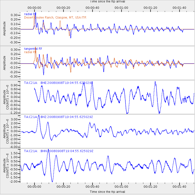
Signal To Noise
| Channel | StoN | STA | LTA |
| TA:C21A: :BHZ:20080908T19:04:55.625029Z | 17.719948 | 1.969146E-6 | 1.11125956E-7 |
| TA:C21A: :BHN:20080908T19:04:55.625029Z | 0.8330038 | 2.3554381E-7 | 2.8276438E-7 |
| TA:C21A: :BHE:20080908T19:04:55.625029Z | 1.6977942 | 5.516561E-7 | 3.2492522E-7 |
| Arrivals |
| Ps | 6.4 SECOND |
| PpPs | 19 SECOND |
| PsPs/PpSs | 25 SECOND |


