You are here: Home > Network List > TA - USArray Transportable Network (new EarthScope stations) Stations List
> Station C21A Desert Coulee Ranch, Glasgow, MT, USA > Earthquake Result Viewer
C21A Desert Coulee Ranch, Glasgow, MT, USA - Earthquake Result Viewer
| Earthquake location: |
Fox Islands, Aleutian Islands |
| Earthquake latitude/longitude: |
52.8/-167.0 |
| Earthquake time(UTC): |
2009/10/13 (286) 05:37:23 GMT |
| Earthquake Depth: |
24 km |
| Earthquake Magnitude: |
6.0 MB, 6.1 MS, 6.5 MW, 6.5 MW |
| Earthquake Catalog/Contributor: |
WHDF/NEIC |
|
| Network: |
TA USArray Transportable Network (new EarthScope stations) |
| Station: |
C21A Desert Coulee Ranch, Glasgow, MT, USA |
| Lat/Lon: |
47.83 N/107.10 W |
| Elevation: |
804 m |
|
| Distance: |
37.6 deg |
| Az: |
72.775 deg |
| Baz: |
300.51 deg |
| Ray Param: |
0.07600047 |
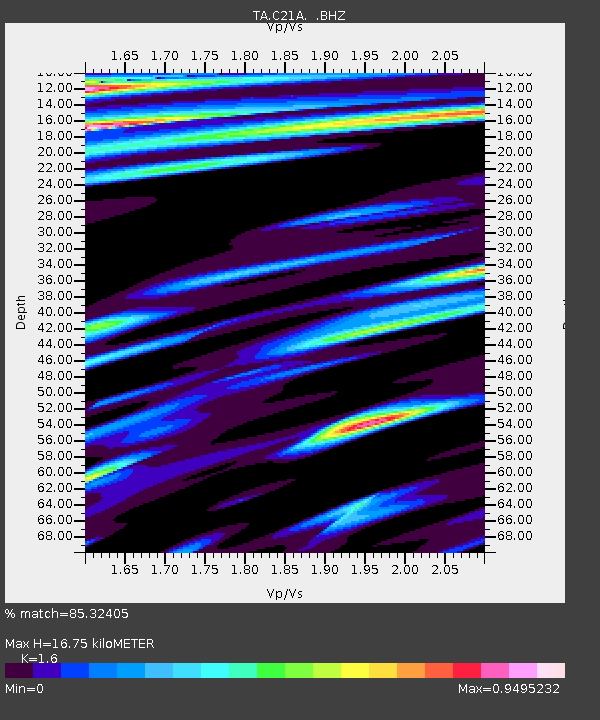
| Estimated Moho Depth: |
16.75 km |
| Estimated Crust Vp/Vs: |
1.60 |
| Assumed Crust Vp: |
6.438 km/s |
| Estimated Crust Vs: |
4.023 km/s |
| Estimated Crust Poisson's Ratio: |
0.18 |
|
| Radial Match: |
85.32405 % |
| Radial Bump: |
400 |
| Transverse Match: |
59.897297 % |
| Transverse Bump: |
400 |
| SOD ConfigId: |
2622 |
| Insert Time: |
2010-03-07 00:49:49.327 +0000 |
| GWidth: |
2.5 |
| Max Bumps: |
400 |
| Tol: |
0.001 |
|

Signal To Noise
| Channel | StoN | STA | LTA |
| TA:C21A: :BHZ:20091013T05:44:05.774015Z | 2.9088972 | 6.293988E-7 | 2.1637025E-7 |
| TA:C21A: :BHN:20091013T05:44:05.774015Z | 1.5343052 | 1.1946147E-6 | 7.7860307E-7 |
| TA:C21A: :BHE:20091013T05:44:05.774015Z | 1.4967184 | 4.935666E-7 | 3.297658E-7 |
| Arrivals |
| Ps | 1.7 SECOND |
| PpPs | 6.2 SECOND |
| PsPs/PpSs | 7.9 SECOND |


