You are here: Home > Network List > IU - Global Seismograph Network (GSN - IRIS/USGS) Stations List
> Station RSSD Black Hills, South Dakota, USA > Earthquake Result Viewer
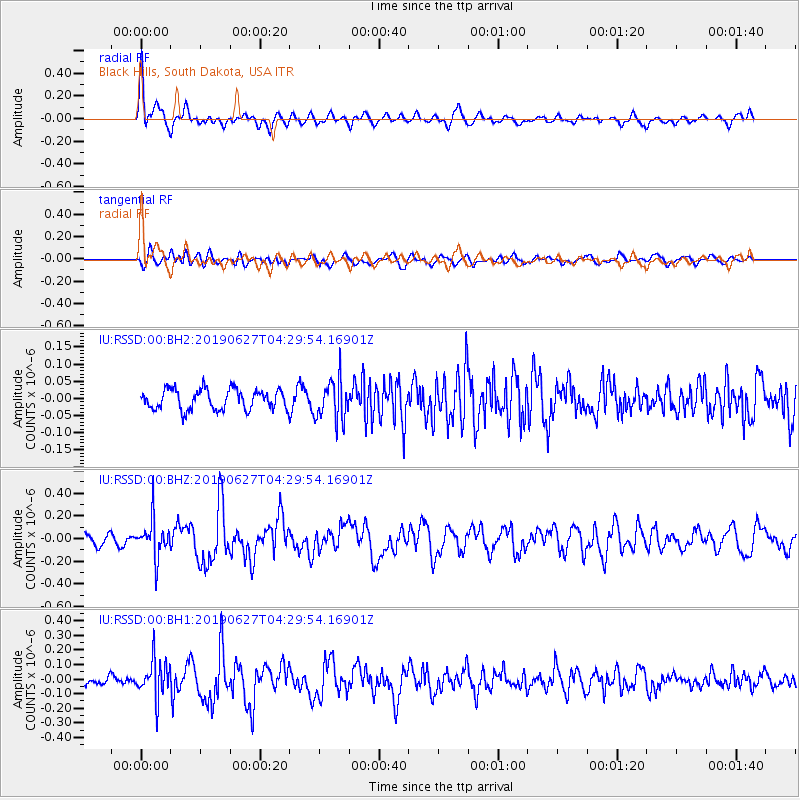
RSSD Black Hills, South Dakota, USA - Earthquake Result Viewer
*The percent match for this event was below the threshold and hence no stack was calculated.
| Earthquake location: |
Komandorskiye Ostrova Region |
| Earthquake latitude/longitude: |
56.2/164.3 |
| Earthquake time(UTC): |
2019/06/27 (178) 04:20:48 GMT |
| Earthquake Depth: |
10 km |
| Earthquake Magnitude: |
5.7 Mww |
| Earthquake Catalog/Contributor: |
NEIC PDE/us |
|
| Network: |
IU Global Seismograph Network (GSN - IRIS/USGS) |
| Station: |
RSSD Black Hills, South Dakota, USA |
| Lat/Lon: |
44.12 N/104.04 W |
| Elevation: |
2090 m |
|
| Distance: |
55.7 deg |
| Az: |
60.637 deg |
| Baz: |
317.438 deg |
| Ray Param: |
$rayparam |
*The percent match for this event was below the threshold and hence was not used in the summary stack. |
|
| Radial Match: |
66.265335 % |
| Radial Bump: |
400 |
| Transverse Match: |
70.20488 % |
| Transverse Bump: |
400 |
| SOD ConfigId: |
18369291 |
| Insert Time: |
2019-07-11 04:24:36.023 +0000 |
| GWidth: |
2.5 |
| Max Bumps: |
400 |
| Tol: |
0.001 |
|
Signal To Noise
| Channel | StoN | STA | LTA |
| IU:RSSD:00:BHZ:20190627T04:29:54.16901Z | 3.0544536 | 1.6973658E-7 | 5.5570194E-8 |
| IU:RSSD:00:BH1:20190627T04:29:54.16901Z | 2.866831 | 1.2779076E-7 | 4.4575614E-8 |
| IU:RSSD:00:BH2:20190627T04:29:54.16901Z | 2.0564373 | 6.039908E-8 | 2.9370739E-8 |
| Arrivals |
| Ps | |
| PpPs | |
| PsPs/PpSs | |


