You are here: Home > Network List > TA - USArray Transportable Network (new EarthScope stations) Stations List
> Station C21A Desert Coulee Ranch, Glasgow, MT, USA > Earthquake Result Viewer
C21A Desert Coulee Ranch, Glasgow, MT, USA - Earthquake Result Viewer
| Earthquake location: |
Off Coast Of Ecuador |
| Earthquake latitude/longitude: |
1.4/-85.2 |
| Earthquake time(UTC): |
2009/05/10 (130) 01:16:06 GMT |
| Earthquake Depth: |
6.0 km |
| Earthquake Magnitude: |
5.5 MB, 5.7 MS, 6.1 MW, 6.1 MW |
| Earthquake Catalog/Contributor: |
WHDF/NEIC |
|
| Network: |
TA USArray Transportable Network (new EarthScope stations) |
| Station: |
C21A Desert Coulee Ranch, Glasgow, MT, USA |
| Lat/Lon: |
47.83 N/107.10 W |
| Elevation: |
804 m |
|
| Distance: |
50.0 deg |
| Az: |
340.824 deg |
| Baz: |
150.836 deg |
| Ray Param: |
0.068352 |
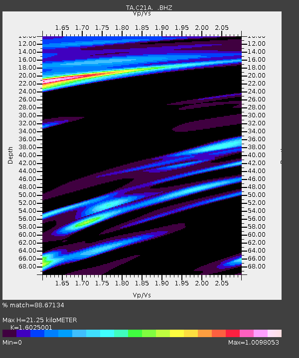
| Estimated Moho Depth: |
21.25 km |
| Estimated Crust Vp/Vs: |
1.60 |
| Assumed Crust Vp: |
6.438 km/s |
| Estimated Crust Vs: |
4.017 km/s |
| Estimated Crust Poisson's Ratio: |
0.18 |
|
| Radial Match: |
88.67134 % |
| Radial Bump: |
338 |
| Transverse Match: |
70.694725 % |
| Transverse Bump: |
400 |
| SOD ConfigId: |
2760 |
| Insert Time: |
2010-03-07 00:50:18.638 +0000 |
| GWidth: |
2.5 |
| Max Bumps: |
400 |
| Tol: |
0.001 |
|
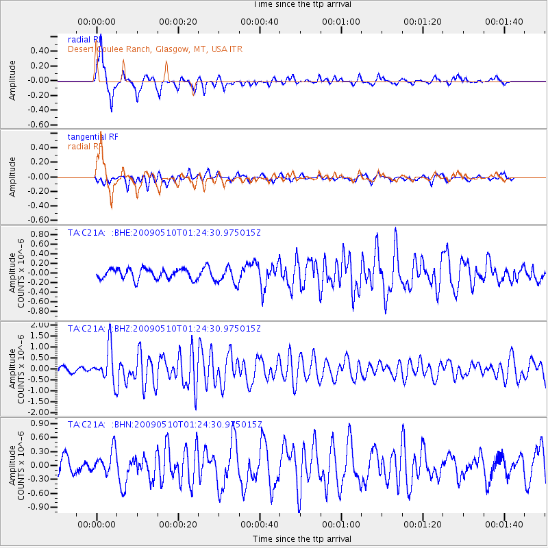
Signal To Noise
| Channel | StoN | STA | LTA |
| TA:C21A: :BHZ:20090510T01:24:30.975015Z | 7.767997 | 8.2354114E-7 | 1.0601718E-7 |
| TA:C21A: :BHN:20090510T01:24:30.975015Z | 1.5507053 | 2.7220455E-7 | 1.7553596E-7 |
| TA:C21A: :BHE:20090510T01:24:30.975015Z | 1.643847 | 1.7291947E-7 | 1.0519195E-7 |
| Arrivals |
| Ps | 2.1 SECOND |
| PpPs | 8.1 SECOND |
| PsPs/PpSs | 10 SECOND |


