You are here: Home > Network List > TA - USArray Transportable Network (new EarthScope stations) Stations List
> Station C21A Desert Coulee Ranch, Glasgow, MT, USA > Earthquake Result Viewer
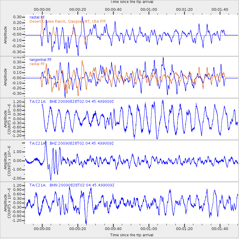
C21A Desert Coulee Ranch, Glasgow, MT, USA - Earthquake Result Viewer
*The percent match for this event was below the threshold and hence no stack was calculated.
| Earthquake location: |
Qinghai, China |
| Earthquake latitude/longitude: |
37.7/95.7 |
| Earthquake time(UTC): |
2009/08/28 (240) 01:52:06 GMT |
| Earthquake Depth: |
13 km |
| Earthquake Magnitude: |
6.2 MB, 6.2 MS, 6.2 MW, 6.2 MW |
| Earthquake Catalog/Contributor: |
WHDF/NEIC |
|
| Network: |
TA USArray Transportable Network (new EarthScope stations) |
| Station: |
C21A Desert Coulee Ranch, Glasgow, MT, USA |
| Lat/Lon: |
47.83 N/107.10 W |
| Elevation: |
804 m |
|
| Distance: |
92.5 deg |
| Az: |
15.16 deg |
| Baz: |
342.07 deg |
| Ray Param: |
$rayparam |
*The percent match for this event was below the threshold and hence was not used in the summary stack. |
|
| Radial Match: |
71.34301 % |
| Radial Bump: |
400 |
| Transverse Match: |
72.04871 % |
| Transverse Bump: |
400 |
| SOD ConfigId: |
2622 |
| Insert Time: |
2010-03-07 00:50:34.469 +0000 |
| GWidth: |
2.5 |
| Max Bumps: |
400 |
| Tol: |
0.001 |
|
Signal To Noise
| Channel | StoN | STA | LTA |
| TA:C21A: :BHZ:20090828T02:04:45.499009Z | 6.2756195 | 1.0201267E-6 | 1.6255393E-7 |
| TA:C21A: :BHN:20090828T02:04:45.499009Z | 1.0397218 | 3.521829E-7 | 3.38728E-7 |
| TA:C21A: :BHE:20090828T02:04:45.499009Z | 0.5966754 | 3.0543265E-7 | 5.118908E-7 |
| Arrivals |
| Ps | |
| PpPs | |
| PsPs/PpSs | |


