You are here: Home > Network List > TA - USArray Transportable Network (new EarthScope stations) Stations List
> Station C21A Desert Coulee Ranch, Glasgow, MT, USA > Earthquake Result Viewer
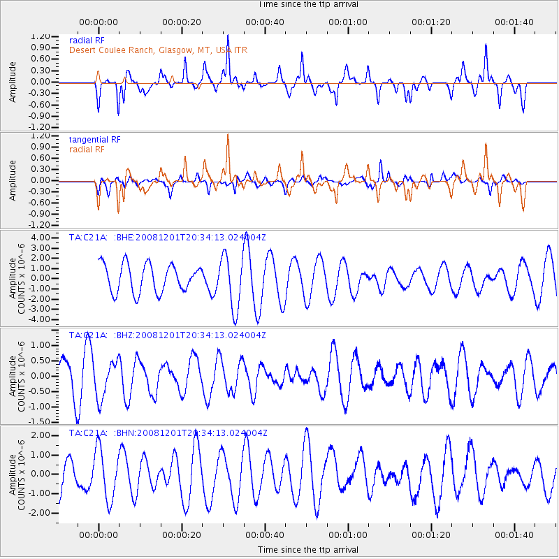
C21A Desert Coulee Ranch, Glasgow, MT, USA - Earthquake Result Viewer
*The percent match for this event was below the threshold and hence no stack was calculated.
| Earthquake location: |
Tonga Islands Region |
| Earthquake latitude/longitude: |
-22.9/-175.2 |
| Earthquake time(UTC): |
2008/12/01 (336) 20:21:34 GMT |
| Earthquake Depth: |
39 km |
| Earthquake Magnitude: |
5.5 MB, 5.1 MS |
| Earthquake Catalog/Contributor: |
WHDF/NEIC |
|
| Network: |
TA USArray Transportable Network (new EarthScope stations) |
| Station: |
C21A Desert Coulee Ranch, Glasgow, MT, USA |
| Lat/Lon: |
47.83 N/107.10 W |
| Elevation: |
804 m |
|
| Distance: |
93.1 deg |
| Az: |
38.765 deg |
| Baz: |
238.933 deg |
| Ray Param: |
$rayparam |
*The percent match for this event was below the threshold and hence was not used in the summary stack. |
|
| Radial Match: |
80.323265 % |
| Radial Bump: |
400 |
| Transverse Match: |
53.02175 % |
| Transverse Bump: |
378 |
| SOD ConfigId: |
2658 |
| Insert Time: |
2010-03-07 00:50:53.320 +0000 |
| GWidth: |
2.5 |
| Max Bumps: |
400 |
| Tol: |
0.001 |
|
Signal To Noise
| Channel | StoN | STA | LTA |
| TA:C21A: :BHZ:20081201T20:34:13.024004Z | 1.0900065 | 6.0185414E-7 | 5.5215645E-7 |
| TA:C21A: :BHN:20081201T20:34:13.024004Z | 0.8491685 | 1.3381273E-6 | 1.5758089E-6 |
| TA:C21A: :BHE:20081201T20:34:13.024004Z | 1.9519804 | 2.65213E-6 | 1.3586869E-6 |
| Arrivals |
| Ps | |
| PpPs | |
| PsPs/PpSs | |


