You are here: Home > Network List > JP - Japan Meteorological Agency Seismic Network Stations List
> Station JTM Aomori Tenma > Earthquake Result Viewer
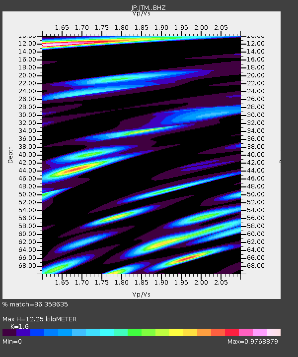
JTM Aomori Tenma - Earthquake Result Viewer
| Earthquake location: |
Kermadec Islands Region |
| Earthquake latitude/longitude: |
-30.4/-179.2 |
| Earthquake time(UTC): |
2019/06/27 (178) 11:04:57 GMT |
| Earthquake Depth: |
10 km |
| Earthquake Magnitude: |
6.3 Mww |
| Earthquake Catalog/Contributor: |
NEIC PDE/us |
|
| Network: |
JP Japan Meteorological Agency Seismic Network |
| Station: |
JTM Aomori Tenma |
| Lat/Lon: |
40.79 N/141.06 E |
| Elevation: |
130 m |
|
| Distance: |
79.8 deg |
| Az: |
330.473 deg |
| Baz: |
145.884 deg |
| Ray Param: |
0.048719857 |
| Estimated Moho Depth: |
12.25 km |
| Estimated Crust Vp/Vs: |
1.60 |
| Assumed Crust Vp: |
6.468 km/s |
| Estimated Crust Vs: |
4.042 km/s |
| Estimated Crust Poisson's Ratio: |
0.18 |
|
| Radial Match: |
86.358635 % |
| Radial Bump: |
400 |
| Transverse Match: |
79.87444 % |
| Transverse Bump: |
400 |
| SOD ConfigId: |
18369291 |
| Insert Time: |
2019-07-11 11:08:34.631 +0000 |
| GWidth: |
2.5 |
| Max Bumps: |
400 |
| Tol: |
0.001 |
|

Signal To Noise
| Channel | StoN | STA | LTA |
| JP:JTM: :BHZ:20190627T11:16:33.900005Z | 3.5622392 | 4.863641E-7 | 1.3653326E-7 |
| JP:JTM: :BHN:20190627T11:16:33.900005Z | 1.7992979 | 1.1627549E-7 | 6.46227E-8 |
| JP:JTM: :BHE:20190627T11:16:33.900005Z | 1.8370132 | 8.1562526E-8 | 4.4399528E-8 |
| Arrivals |
| Ps | 1.2 SECOND |
| PpPs | 4.8 SECOND |
| PsPs/PpSs | 5.9 SECOND |


