You are here: Home > Network List > TA - USArray Transportable Network (new EarthScope stations) Stations List
> Station C21A Desert Coulee Ranch, Glasgow, MT, USA > Earthquake Result Viewer
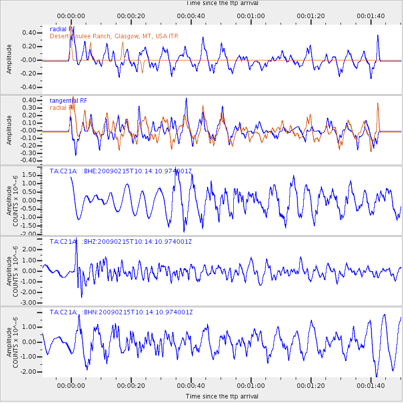
C21A Desert Coulee Ranch, Glasgow, MT, USA - Earthquake Result Viewer
*The percent match for this event was below the threshold and hence no stack was calculated.
| Earthquake location: |
Near Coast Of Northern Peru |
| Earthquake latitude/longitude: |
-5.9/-80.9 |
| Earthquake time(UTC): |
2009/02/15 (046) 10:04:49 GMT |
| Earthquake Depth: |
21 km |
| Earthquake Magnitude: |
5.8 MB, 5.7 MS, 6.1 MW, 6.1 MW |
| Earthquake Catalog/Contributor: |
WHDF/NEIC |
|
| Network: |
TA USArray Transportable Network (new EarthScope stations) |
| Station: |
C21A Desert Coulee Ranch, Glasgow, MT, USA |
| Lat/Lon: |
47.83 N/107.10 W |
| Elevation: |
804 m |
|
| Distance: |
58.2 deg |
| Az: |
339.511 deg |
| Baz: |
148.884 deg |
| Ray Param: |
$rayparam |
*The percent match for this event was below the threshold and hence was not used in the summary stack. |
|
| Radial Match: |
53.149757 % |
| Radial Bump: |
366 |
| Transverse Match: |
47.061264 % |
| Transverse Bump: |
299 |
| SOD ConfigId: |
2658 |
| Insert Time: |
2010-03-07 00:51:33.336 +0000 |
| GWidth: |
2.5 |
| Max Bumps: |
400 |
| Tol: |
0.001 |
|
Signal To Noise
| Channel | StoN | STA | LTA |
| TA:C21A: :BHZ:20090215T10:14:10.974001Z | 2.7842681 | 1.1225724E-6 | 4.03184E-7 |
| TA:C21A: :BHN:20090215T10:14:10.974001Z | 1.6604325 | 8.501821E-7 | 5.120245E-7 |
| TA:C21A: :BHE:20090215T10:14:10.974001Z | 1.6802113 | 8.925724E-7 | 5.312263E-7 |
| Arrivals |
| Ps | |
| PpPs | |
| PsPs/PpSs | |


