You are here: Home > Network List > PF - Volcanologic Network of Piton de Fournaise-OVPF Stations List
> Station GPS Grandes Pentes Sud > Earthquake Result Viewer
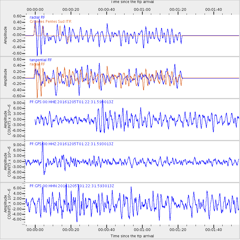
GPS Grandes Pentes Sud - Earthquake Result Viewer
*The percent match for this event was below the threshold and hence no stack was calculated.
| Earthquake location: |
Banda Sea |
| Earthquake latitude/longitude: |
-7.3/123.4 |
| Earthquake time(UTC): |
2016/12/05 (340) 01:13:04 GMT |
| Earthquake Depth: |
526 km |
| Earthquake Magnitude: |
6.3 Mww |
| Earthquake Catalog/Contributor: |
NEIC PDE/us |
|
| Network: |
PF Volcanologic Network of Piton de Fournaise-OVPF |
| Station: |
GPS Grandes Pentes Sud |
| Lat/Lon: |
21.27 S/55.76 E |
| Elevation: |
1004 m |
|
| Distance: |
66.6 deg |
| Az: |
250.066 deg |
| Baz: |
88.862 deg |
| Ray Param: |
$rayparam |
*The percent match for this event was below the threshold and hence was not used in the summary stack. |
|
| Radial Match: |
62.261475 % |
| Radial Bump: |
400 |
| Transverse Match: |
60.23007 % |
| Transverse Bump: |
400 |
| SOD ConfigId: |
1894071 |
| Insert Time: |
2016-12-19 01:15:07.603 +0000 |
| GWidth: |
2.5 |
| Max Bumps: |
400 |
| Tol: |
0.001 |
|
Signal To Noise
| Channel | StoN | STA | LTA |
| PF:GPS:00:HHZ:20161205T01:22:31.593013Z | 3.4546597 | 3.3116992E-6 | 9.586181E-7 |
| PF:GPS:00:HHN:20161205T01:22:31.593013Z | 1.8080264 | 2.8452887E-6 | 1.5736986E-6 |
| PF:GPS:00:HHE:20161205T01:22:31.593013Z | 1.2316419 | 1.877826E-6 | 1.5246526E-6 |
| Arrivals |
| Ps | |
| PpPs | |
| PsPs/PpSs | |


