You are here: Home > Network List > CN - Canadian National Seismograph Network Stations List
> Station KUKN Kugluktuk, NT, CA > Earthquake Result Viewer
KUKN Kugluktuk, NT, CA - Earthquake Result Viewer
| Earthquake location: |
Mariana Islands |
| Earthquake latitude/longitude: |
19.9/144.9 |
| Earthquake time(UTC): |
2019/06/28 (179) 15:51:32 GMT |
| Earthquake Depth: |
460 km |
| Earthquake Magnitude: |
6.5 Mi |
| Earthquake Catalog/Contributor: |
NEIC PDE/at |
|
| Network: |
CN Canadian National Seismograph Network |
| Station: |
KUKN Kugluktuk, NT, CA |
| Lat/Lon: |
67.82 N/115.09 W |
| Elevation: |
51 m |
|
| Distance: |
75.5 deg |
| Az: |
22.72 deg |
| Baz: |
286.8 deg |
| Ray Param: |
0.050255634 |
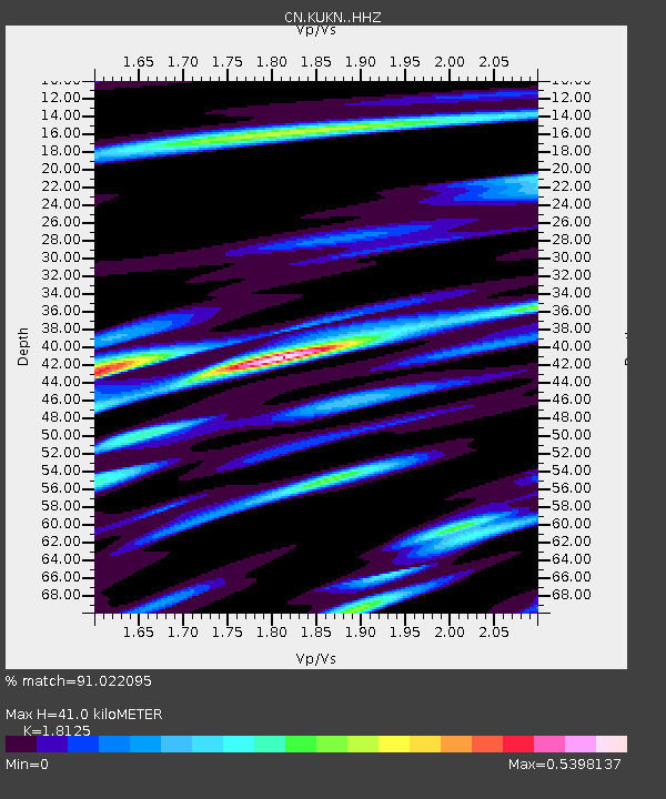
| Estimated Moho Depth: |
41.0 km |
| Estimated Crust Vp/Vs: |
1.81 |
| Assumed Crust Vp: |
6.459 km/s |
| Estimated Crust Vs: |
3.564 km/s |
| Estimated Crust Poisson's Ratio: |
0.28 |
|
| Radial Match: |
91.022095 % |
| Radial Bump: |
314 |
| Transverse Match: |
75.309044 % |
| Transverse Bump: |
400 |
| SOD ConfigId: |
18369291 |
| Insert Time: |
2019-07-12 15:54:43.075 +0000 |
| GWidth: |
2.5 |
| Max Bumps: |
400 |
| Tol: |
0.001 |
|

Signal To Noise
| Channel | StoN | STA | LTA |
| CN:KUKN: :HHZ:20190628T16:01:56.820007Z | 5.479819 | 2.7916246E-7 | 5.0943743E-8 |
| CN:KUKN: :HHN:20190628T16:01:56.820007Z | 1.8971243 | 7.793145E-8 | 4.1078728E-8 |
| CN:KUKN: :HHE:20190628T16:01:56.820007Z | 3.1923769 | 1.2139645E-7 | 3.8026982E-8 |
| Arrivals |
| Ps | 5.3 SECOND |
| PpPs | 17 SECOND |
| PsPs/PpSs | 23 SECOND |


