You are here: Home > Network List > TA - USArray Transportable Network (new EarthScope stations) Stations List
> Station A24A Westby, ND, USA > Earthquake Result Viewer
A24A Westby, ND, USA - Earthquake Result Viewer
| Earthquake location: |
Near S. Coast Of Honshu, Japan |
| Earthquake latitude/longitude: |
33.2/137.9 |
| Earthquake time(UTC): |
2009/08/09 (221) 10:55:55 GMT |
| Earthquake Depth: |
297 km |
| Earthquake Magnitude: |
6.5 MB, 7.1 MW, 7.1 MW |
| Earthquake Catalog/Contributor: |
WHDF/NEIC |
|
| Network: |
TA USArray Transportable Network (new EarthScope stations) |
| Station: |
A24A Westby, ND, USA |
| Lat/Lon: |
48.92 N/104.00 W |
| Elevation: |
677 m |
|
| Distance: |
81.4 deg |
| Az: |
36.06 deg |
| Baz: |
311.535 deg |
| Ray Param: |
0.046817135 |
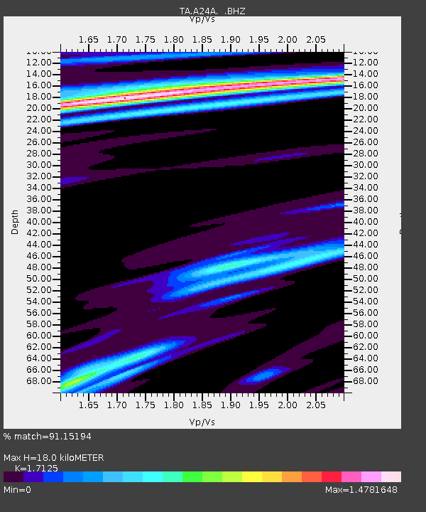
| Estimated Moho Depth: |
18.0 km |
| Estimated Crust Vp/Vs: |
1.71 |
| Assumed Crust Vp: |
6.438 km/s |
| Estimated Crust Vs: |
3.759 km/s |
| Estimated Crust Poisson's Ratio: |
0.24 |
|
| Radial Match: |
91.15194 % |
| Radial Bump: |
400 |
| Transverse Match: |
77.18986 % |
| Transverse Bump: |
400 |
| SOD ConfigId: |
2622 |
| Insert Time: |
2010-03-07 00:51:39.377 +0000 |
| GWidth: |
2.5 |
| Max Bumps: |
400 |
| Tol: |
0.001 |
|
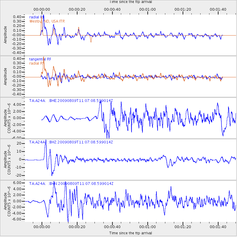
Signal To Noise
| Channel | StoN | STA | LTA |
| TA:A24A: :BHZ:20090809T11:07:08.599014Z | 72.913124 | 9.978601E-6 | 1.3685603E-7 |
| TA:A24A: :BHN:20090809T11:07:08.599014Z | 7.265079 | 2.173938E-6 | 2.9923115E-7 |
| TA:A24A: :BHE:20090809T11:07:08.599014Z | 5.099041 | 2.3239795E-6 | 4.55768E-7 |
| Arrivals |
| Ps | 2.0 SECOND |
| PpPs | 7.4 SECOND |
| PsPs/PpSs | 9.4 SECOND |


