You are here: Home > Network List > TA - USArray Transportable Network (new EarthScope stations) Stations List
> Station A24A Westby, ND, USA > Earthquake Result Viewer
A24A Westby, ND, USA - Earthquake Result Viewer
| Earthquake location: |
Off Coast Of Ecuador |
| Earthquake latitude/longitude: |
1.4/-85.2 |
| Earthquake time(UTC): |
2009/05/10 (130) 01:16:06 GMT |
| Earthquake Depth: |
6.0 km |
| Earthquake Magnitude: |
5.5 MB, 5.7 MS, 6.1 MW, 6.1 MW |
| Earthquake Catalog/Contributor: |
WHDF/NEIC |
|
| Network: |
TA USArray Transportable Network (new EarthScope stations) |
| Station: |
A24A Westby, ND, USA |
| Lat/Lon: |
48.92 N/104.00 W |
| Elevation: |
677 m |
|
| Distance: |
50.0 deg |
| Az: |
343.873 deg |
| Baz: |
155.101 deg |
| Ray Param: |
0.06832624 |
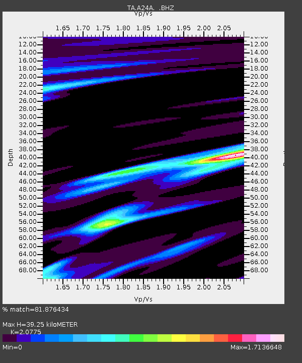
| Estimated Moho Depth: |
39.25 km |
| Estimated Crust Vp/Vs: |
2.08 |
| Assumed Crust Vp: |
6.438 km/s |
| Estimated Crust Vs: |
3.099 km/s |
| Estimated Crust Poisson's Ratio: |
0.35 |
|
| Radial Match: |
81.876434 % |
| Radial Bump: |
400 |
| Transverse Match: |
47.69549 % |
| Transverse Bump: |
385 |
| SOD ConfigId: |
2760 |
| Insert Time: |
2010-03-07 00:51:44.724 +0000 |
| GWidth: |
2.5 |
| Max Bumps: |
400 |
| Tol: |
0.001 |
|
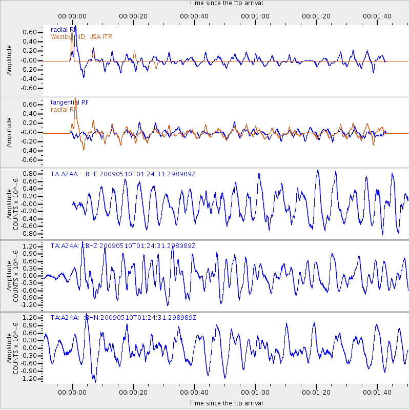
Signal To Noise
| Channel | StoN | STA | LTA |
| TA:A24A: :BHZ:20090510T01:24:31.298989Z | 6.1137266 | 5.2959274E-7 | 8.6623565E-8 |
| TA:A24A: :BHN:20090510T01:24:31.298989Z | 1.8064243 | 5.632856E-7 | 3.1182353E-7 |
| TA:A24A: :BHE:20090510T01:24:31.298989Z | 0.75953853 | 2.5343667E-7 | 3.336719E-7 |
| Arrivals |
| Ps | 6.9 SECOND |
| PpPs | 18 SECOND |
| PsPs/PpSs | 25 SECOND |


