You are here: Home > Network List > TA - USArray Transportable Network (new EarthScope stations) Stations List
> Station H23K Yukon River, AK, USA > Earthquake Result Viewer
H23K Yukon River, AK, USA - Earthquake Result Viewer
| Earthquake location: |
Mariana Islands |
| Earthquake latitude/longitude: |
19.9/144.9 |
| Earthquake time(UTC): |
2019/06/28 (179) 15:51:32 GMT |
| Earthquake Depth: |
460 km |
| Earthquake Magnitude: |
6.5 Mi |
| Earthquake Catalog/Contributor: |
NEIC PDE/at |
|
| Network: |
TA USArray Transportable Network (new EarthScope stations) |
| Station: |
H23K Yukon River, AK, USA |
| Lat/Lon: |
65.83 N/149.54 W |
| Elevation: |
617 m |
|
| Distance: |
62.1 deg |
| Az: |
25.113 deg |
| Baz: |
255.881 deg |
| Ray Param: |
0.058821917 |
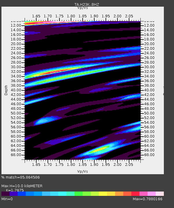
| Estimated Moho Depth: |
10.0 km |
| Estimated Crust Vp/Vs: |
1.77 |
| Assumed Crust Vp: |
6.566 km/s |
| Estimated Crust Vs: |
3.715 km/s |
| Estimated Crust Poisson's Ratio: |
0.26 |
|
| Radial Match: |
85.864586 % |
| Radial Bump: |
400 |
| Transverse Match: |
76.486206 % |
| Transverse Bump: |
400 |
| SOD ConfigId: |
18369291 |
| Insert Time: |
2019-07-12 15:57:14.995 +0000 |
| GWidth: |
2.5 |
| Max Bumps: |
400 |
| Tol: |
0.001 |
|

Signal To Noise
| Channel | StoN | STA | LTA |
| TA:H23K: :BHZ:20190628T16:00:35.700012Z | 0.98822695 | 4.333446E-8 | 4.385072E-8 |
| TA:H23K: :BHN:20190628T16:00:35.700012Z | 0.9416052 | 3.7194525E-8 | 3.9501188E-8 |
| TA:H23K: :BHE:20190628T16:00:35.700012Z | 3.0181038 | 7.789633E-8 | 2.5809692E-8 |
| Arrivals |
| Ps | 1.2 SECOND |
| PpPs | 4.0 SECOND |
| PsPs/PpSs | 5.3 SECOND |


