You are here: Home > Network List > TA - USArray Transportable Network (new EarthScope stations) Stations List
> Station J25K Salcha River, AK, USA > Earthquake Result Viewer
J25K Salcha River, AK, USA - Earthquake Result Viewer
| Earthquake location: |
Mariana Islands |
| Earthquake latitude/longitude: |
19.9/144.9 |
| Earthquake time(UTC): |
2019/06/28 (179) 15:51:32 GMT |
| Earthquake Depth: |
460 km |
| Earthquake Magnitude: |
6.5 Mi |
| Earthquake Catalog/Contributor: |
NEIC PDE/at |
|
| Network: |
TA USArray Transportable Network (new EarthScope stations) |
| Station: |
J25K Salcha River, AK, USA |
| Lat/Lon: |
64.61 N/145.37 W |
| Elevation: |
949 m |
|
| Distance: |
63.5 deg |
| Az: |
26.858 deg |
| Baz: |
260.464 deg |
| Ray Param: |
0.057895463 |
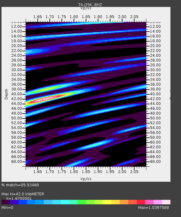
| Estimated Moho Depth: |
42.0 km |
| Estimated Crust Vp/Vs: |
1.67 |
| Assumed Crust Vp: |
6.566 km/s |
| Estimated Crust Vs: |
3.932 km/s |
| Estimated Crust Poisson's Ratio: |
0.22 |
|
| Radial Match: |
85.53468 % |
| Radial Bump: |
400 |
| Transverse Match: |
63.502537 % |
| Transverse Bump: |
400 |
| SOD ConfigId: |
18369291 |
| Insert Time: |
2019-07-12 15:57:19.544 +0000 |
| GWidth: |
2.5 |
| Max Bumps: |
400 |
| Tol: |
0.001 |
|

Signal To Noise
| Channel | StoN | STA | LTA |
| TA:J25K: :BHZ:20190628T16:00:45.200012Z | 24.917099 | 7.408702E-7 | 2.9733405E-8 |
| TA:J25K: :BHN:20190628T16:00:45.200012Z | 1.8642112 | 3.8504048E-8 | 2.0654339E-8 |
| TA:J25K: :BHE:20190628T16:00:45.200012Z | 13.832641 | 3.9252544E-7 | 2.8376753E-8 |
| Arrivals |
| Ps | 4.5 SECOND |
| PpPs | 16 SECOND |
| PsPs/PpSs | 21 SECOND |


