You are here: Home > Network List > TA - USArray Transportable Network (new EarthScope stations) Stations List
> Station M30M Minto, Yukon, CA > Earthquake Result Viewer
M30M Minto, Yukon, CA - Earthquake Result Viewer
| Earthquake location: |
Mariana Islands |
| Earthquake latitude/longitude: |
19.9/144.9 |
| Earthquake time(UTC): |
2019/06/28 (179) 15:51:32 GMT |
| Earthquake Depth: |
460 km |
| Earthquake Magnitude: |
6.5 Mi |
| Earthquake Catalog/Contributor: |
NEIC PDE/at |
|
| Network: |
TA USArray Transportable Network (new EarthScope stations) |
| Station: |
M30M Minto, Yukon, CA |
| Lat/Lon: |
62.58 N/136.79 W |
| Elevation: |
782 m |
|
| Distance: |
67.2 deg |
| Az: |
29.471 deg |
| Baz: |
269.23 deg |
| Ray Param: |
0.055597737 |
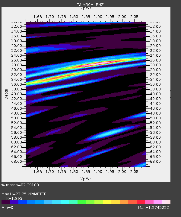
| Estimated Moho Depth: |
27.25 km |
| Estimated Crust Vp/Vs: |
1.89 |
| Assumed Crust Vp: |
6.566 km/s |
| Estimated Crust Vs: |
3.465 km/s |
| Estimated Crust Poisson's Ratio: |
0.31 |
|
| Radial Match: |
87.29183 % |
| Radial Bump: |
400 |
| Transverse Match: |
78.13045 % |
| Transverse Bump: |
400 |
| SOD ConfigId: |
18369291 |
| Insert Time: |
2019-07-12 15:57:25.503 +0000 |
| GWidth: |
2.5 |
| Max Bumps: |
400 |
| Tol: |
0.001 |
|

Signal To Noise
| Channel | StoN | STA | LTA |
| TA:M30M: :BHZ:20190628T16:01:08.049988Z | 1.0694114 | 4.7742635E-8 | 4.464384E-8 |
| TA:M30M: :BHN:20190628T16:01:08.049988Z | 1.2566547 | 3.6988748E-8 | 2.9434295E-8 |
| TA:M30M: :BHE:20190628T16:01:08.049988Z | 1.7174287 | 6.89328E-8 | 4.0137213E-8 |
| Arrivals |
| Ps | 3.9 SECOND |
| PpPs | 12 SECOND |
| PsPs/PpSs | 15 SECOND |


