You are here: Home > Network List > WY - Yellowstone Wyoming Seismic Network Stations List
> Station YNR Norris Junction, YNP, WY, USA > Earthquake Result Viewer
YNR Norris Junction, YNP, WY, USA - Earthquake Result Viewer
| Earthquake location: |
Mariana Islands |
| Earthquake latitude/longitude: |
19.9/144.9 |
| Earthquake time(UTC): |
2019/06/28 (179) 15:51:32 GMT |
| Earthquake Depth: |
460 km |
| Earthquake Magnitude: |
6.5 Mi |
| Earthquake Catalog/Contributor: |
NEIC PDE/at |
|
| Network: |
WY Yellowstone Wyoming Seismic Network |
| Station: |
YNR Norris Junction, YNP, WY, USA |
| Lat/Lon: |
44.72 N/110.68 W |
| Elevation: |
2336 m |
|
| Distance: |
86.0 deg |
| Az: |
43.805 deg |
| Baz: |
293.99 deg |
| Ray Param: |
0.043138288 |
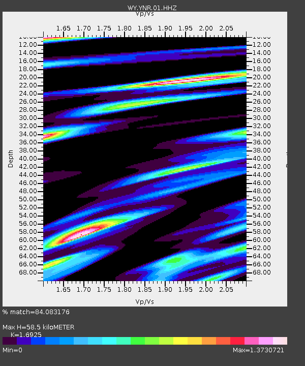
| Estimated Moho Depth: |
58.5 km |
| Estimated Crust Vp/Vs: |
1.69 |
| Assumed Crust Vp: |
6.35 km/s |
| Estimated Crust Vs: |
3.752 km/s |
| Estimated Crust Poisson's Ratio: |
0.23 |
|
| Radial Match: |
84.083176 % |
| Radial Bump: |
400 |
| Transverse Match: |
71.509674 % |
| Transverse Bump: |
400 |
| SOD ConfigId: |
18369291 |
| Insert Time: |
2019-07-12 15:58:26.537 +0000 |
| GWidth: |
2.5 |
| Max Bumps: |
400 |
| Tol: |
0.001 |
|
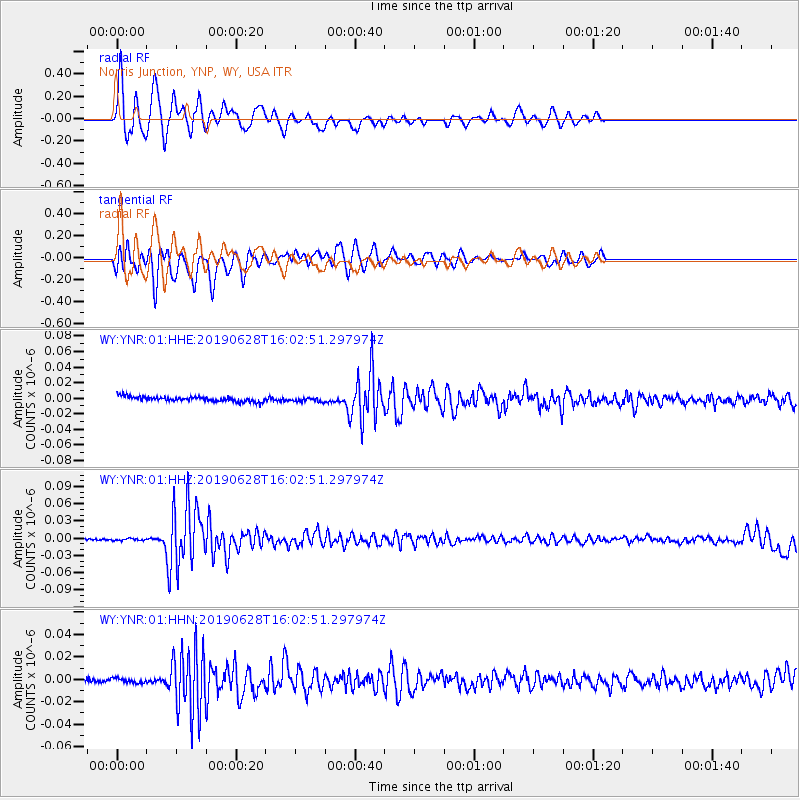
Signal To Noise
| Channel | StoN | STA | LTA |
| WY:YNR:01:HHZ:20190628T16:02:51.297974Z | 1.2388207 | 1.7534932E-9 | 1.4154536E-9 |
| WY:YNR:01:HHN:20190628T16:02:51.297974Z | 0.85333335 | 2.1751279E-9 | 2.5489781E-9 |
| WY:YNR:01:HHE:20190628T16:02:51.297974Z | 0.8346275 | 2.6009983E-9 | 3.1163583E-9 |
| Arrivals |
| Ps | 6.5 SECOND |
| PpPs | 24 SECOND |
| PsPs/PpSs | 31 SECOND |


