You are here: Home > Network List > TA - USArray Transportable Network (new EarthScope stations) Stations List
> Station A24A Westby, ND, USA > Earthquake Result Viewer
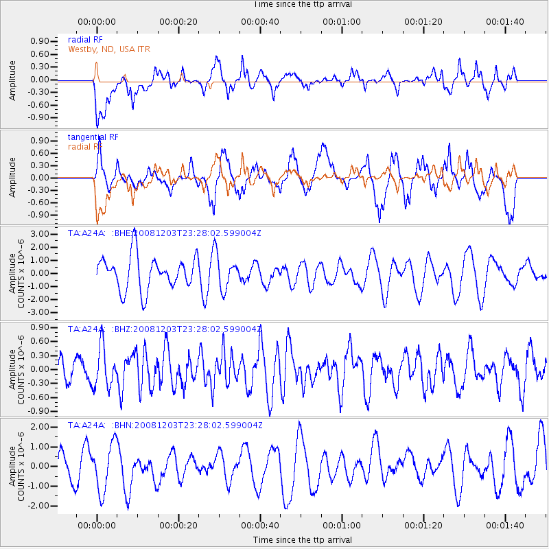
A24A Westby, ND, USA - Earthquake Result Viewer
*The percent match for this event was below the threshold and hence no stack was calculated.
| Earthquake location: |
Near East Coast Of Honshu, Japan |
| Earthquake latitude/longitude: |
38.6/142.9 |
| Earthquake time(UTC): |
2008/12/03 (338) 23:16:54 GMT |
| Earthquake Depth: |
14 km |
| Earthquake Magnitude: |
5.6 MB, 5.5 MS, 5.8 MW, 5.8 MW |
| Earthquake Catalog/Contributor: |
WHDF/NEIC |
|
| Network: |
TA USArray Transportable Network (new EarthScope stations) |
| Station: |
A24A Westby, ND, USA |
| Lat/Lon: |
48.92 N/104.00 W |
| Elevation: |
677 m |
|
| Distance: |
74.7 deg |
| Az: |
38.968 deg |
| Baz: |
311.649 deg |
| Ray Param: |
$rayparam |
*The percent match for this event was below the threshold and hence was not used in the summary stack. |
|
| Radial Match: |
47.96776 % |
| Radial Bump: |
400 |
| Transverse Match: |
58.82552 % |
| Transverse Bump: |
400 |
| SOD ConfigId: |
2658 |
| Insert Time: |
2010-03-07 00:52:33.277 +0000 |
| GWidth: |
2.5 |
| Max Bumps: |
400 |
| Tol: |
0.001 |
|
Signal To Noise
| Channel | StoN | STA | LTA |
| TA:A24A: :BHZ:20081203T23:28:02.599004Z | 1.1554323 | 4.3655817E-7 | 3.77831E-7 |
| TA:A24A: :BHN:20081203T23:28:02.599004Z | 1.4270928 | 1.2679077E-6 | 8.8845496E-7 |
| TA:A24A: :BHE:20081203T23:28:02.599004Z | 0.94001883 | 1.2020724E-6 | 1.2787749E-6 |
| Arrivals |
| Ps | |
| PpPs | |
| PsPs/PpSs | |


