You are here: Home > Network List > TA - USArray Transportable Network (new EarthScope stations) Stations List
> Station A24A Westby, ND, USA > Earthquake Result Viewer
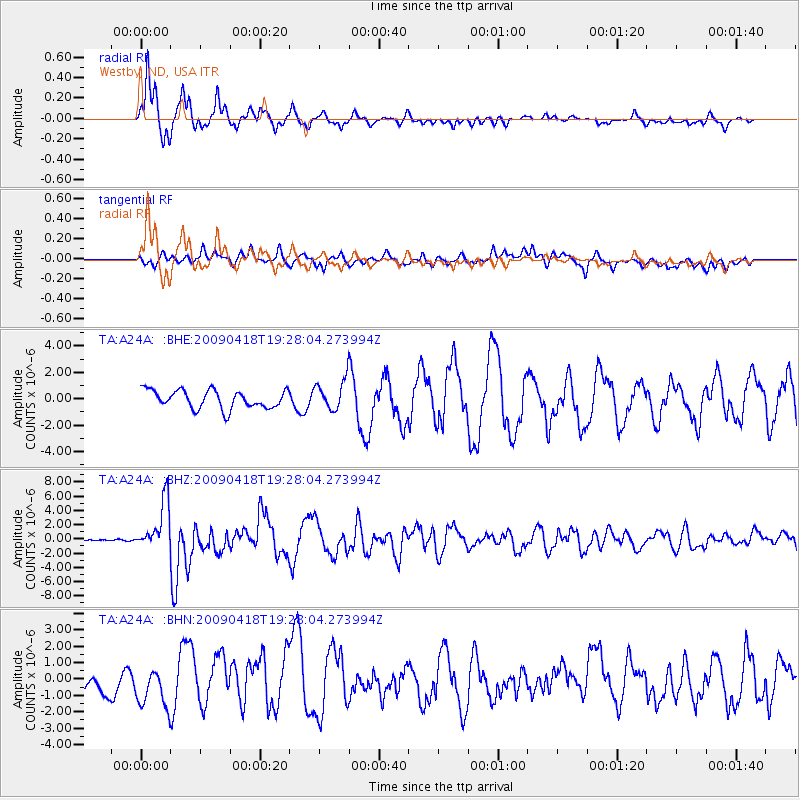
A24A Westby, ND, USA - Earthquake Result Viewer
*The percent match for this event was below the threshold and hence no stack was calculated.
| Earthquake location: |
Kuril Islands |
| Earthquake latitude/longitude: |
46.0/151.4 |
| Earthquake time(UTC): |
2009/04/18 (108) 19:17:58 GMT |
| Earthquake Depth: |
35 km |
| Earthquake Magnitude: |
6.3 MB, 6.3 MS, 6.6 MW, 6.4 MW |
| Earthquake Catalog/Contributor: |
WHDF/NEIC |
|
| Network: |
TA USArray Transportable Network (new EarthScope stations) |
| Station: |
A24A Westby, ND, USA |
| Lat/Lon: |
48.92 N/104.00 W |
| Elevation: |
677 m |
|
| Distance: |
64.9 deg |
| Az: |
44.8 deg |
| Baz: |
311.883 deg |
| Ray Param: |
$rayparam |
*The percent match for this event was below the threshold and hence was not used in the summary stack. |
|
| Radial Match: |
91.41031 % |
| Radial Bump: |
393 |
| Transverse Match: |
61.987766 % |
| Transverse Bump: |
400 |
| SOD ConfigId: |
2658 |
| Insert Time: |
2010-03-07 00:52:35.671 +0000 |
| GWidth: |
2.5 |
| Max Bumps: |
400 |
| Tol: |
0.001 |
|
Signal To Noise
| Channel | StoN | STA | LTA |
| TA:A24A: :BHZ:20090418T19:28:04.273994Z | 22.916714 | 3.403297E-6 | 1.4850718E-7 |
| TA:A24A: :BHN:20090418T19:28:04.273994Z | 1.3464005 | 1.3244387E-6 | 9.836886E-7 |
| TA:A24A: :BHE:20090418T19:28:04.273994Z | 1.6656945 | 1.139558E-6 | 6.841339E-7 |
| Arrivals |
| Ps | |
| PpPs | |
| PsPs/PpSs | |


