You are here: Home > Network List > AV - Alaska Volcano Observatory Stations List
> Station SPBG Barrier Glacier, Mount Spurr, Alaska > Earthquake Result Viewer
SPBG Barrier Glacier, Mount Spurr, Alaska - Earthquake Result Viewer
| Earthquake location: |
Mindanao, Philippines |
| Earthquake latitude/longitude: |
9.1/124.2 |
| Earthquake time(UTC): |
2019/07/01 (182) 16:59:25 GMT |
| Earthquake Depth: |
538 km |
| Earthquake Magnitude: |
5.9 Mww |
| Earthquake Catalog/Contributor: |
NEIC PDE/us |
|
| Network: |
AV Alaska Volcano Observatory |
| Station: |
SPBG Barrier Glacier, Mount Spurr, Alaska |
| Lat/Lon: |
61.26 N/152.37 W |
| Elevation: |
1087 m |
|
| Distance: |
78.9 deg |
| Az: |
29.297 deg |
| Baz: |
268.671 deg |
| Ray Param: |
0.04771078 |
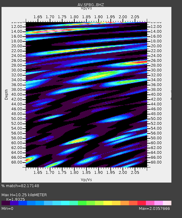
| Estimated Moho Depth: |
10.25 km |
| Estimated Crust Vp/Vs: |
1.93 |
| Assumed Crust Vp: |
6.566 km/s |
| Estimated Crust Vs: |
3.398 km/s |
| Estimated Crust Poisson's Ratio: |
0.32 |
|
| Radial Match: |
82.17148 % |
| Radial Bump: |
400 |
| Transverse Match: |
72.91576 % |
| Transverse Bump: |
400 |
| SOD ConfigId: |
18369291 |
| Insert Time: |
2019-07-15 17:02:31.359 +0000 |
| GWidth: |
2.5 |
| Max Bumps: |
400 |
| Tol: |
0.001 |
|

Signal To Noise
| Channel | StoN | STA | LTA |
| AV:SPBG: :BHZ:20190701T17:10:02.100019Z | 11.692746 | 1.2958453E-6 | 1.1082472E-7 |
| AV:SPBG: :BHN:20190701T17:10:02.100019Z | 6.1987343 | 1.1334441E-6 | 1.8285091E-7 |
| AV:SPBG: :BHE:20190701T17:10:02.100019Z | 13.460949 | 1.9345043E-6 | 1.4371233E-7 |
| Arrivals |
| Ps | 1.5 SECOND |
| PpPs | 4.5 SECOND |
| PsPs/PpSs | 6.0 SECOND |


