You are here: Home > Network List > MM - Myanmar National Seismic Network Stations List
> Station TMU Tamu, Sagaing, Myanmar > Earthquake Result Viewer
TMU Tamu, Sagaing, Myanmar - Earthquake Result Viewer
| Earthquake location: |
Mindanao, Philippines |
| Earthquake latitude/longitude: |
9.1/124.2 |
| Earthquake time(UTC): |
2019/07/01 (182) 16:59:25 GMT |
| Earthquake Depth: |
538 km |
| Earthquake Magnitude: |
5.9 Mww |
| Earthquake Catalog/Contributor: |
NEIC PDE/us |
|
| Network: |
MM Myanmar National Seismic Network |
| Station: |
TMU Tamu, Sagaing, Myanmar |
| Lat/Lon: |
24.23 N/94.30 E |
| Elevation: |
182 m |
|
| Distance: |
32.2 deg |
| Az: |
301.421 deg |
| Baz: |
112.628 deg |
| Ray Param: |
0.07631375 |
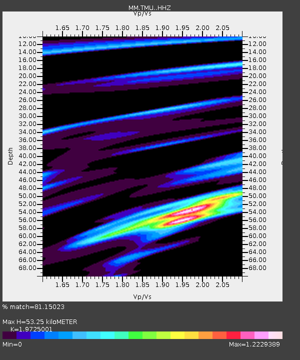
| Estimated Moho Depth: |
53.25 km |
| Estimated Crust Vp/Vs: |
1.97 |
| Assumed Crust Vp: |
6.316 km/s |
| Estimated Crust Vs: |
3.202 km/s |
| Estimated Crust Poisson's Ratio: |
0.33 |
|
| Radial Match: |
81.15023 % |
| Radial Bump: |
400 |
| Transverse Match: |
52.33395 % |
| Transverse Bump: |
400 |
| SOD ConfigId: |
18369291 |
| Insert Time: |
2019-07-15 17:04:05.095 +0000 |
| GWidth: |
2.5 |
| Max Bumps: |
400 |
| Tol: |
0.001 |
|

Signal To Noise
| Channel | StoN | STA | LTA |
| MM:TMU: :HHZ:20190701T17:04:39.397992Z | 27.31914 | 2.3614195E-6 | 8.6438284E-8 |
| MM:TMU: :HHN:20190701T17:04:39.397992Z | 25.154856 | 1.6636676E-6 | 6.6137034E-8 |
| MM:TMU: :HHE:20190701T17:04:39.397992Z | 8.884439 | 1.8990373E-6 | 2.1374869E-7 |
| Arrivals |
| Ps | 8.7 SECOND |
| PpPs | 24 SECOND |
| PsPs/PpSs | 32 SECOND |


