You are here: Home > Network List > US - United States National Seismic Network Stations List
> Station DGMT Dagmar, Montana, USA > Earthquake Result Viewer
DGMT Dagmar, Montana, USA - Earthquake Result Viewer
*The percent match for this event was below the threshold and hence no stack was calculated.
| Earthquake location: |
Windward Islands |
| Earthquake latitude/longitude: |
11.1/-60.9 |
| Earthquake time(UTC): |
2016/12/06 (341) 21:42:21 GMT |
| Earthquake Depth: |
35 km |
| Earthquake Magnitude: |
5.9 Mww |
| Earthquake Catalog/Contributor: |
NEIC PDE/us |
|
| Network: |
US United States National Seismic Network |
| Station: |
DGMT Dagmar, Montana, USA |
| Lat/Lon: |
48.47 N/104.20 W |
| Elevation: |
0.0 m |
|
| Distance: |
51.8 deg |
| Az: |
324.522 deg |
| Baz: |
121.12 deg |
| Ray Param: |
$rayparam |
*The percent match for this event was below the threshold and hence was not used in the summary stack. |
|
| Radial Match: |
51.305714 % |
| Radial Bump: |
400 |
| Transverse Match: |
46.830124 % |
| Transverse Bump: |
367 |
| SOD ConfigId: |
1894071 |
| Insert Time: |
2016-12-20 21:45:25.954 +0000 |
| GWidth: |
2.5 |
| Max Bumps: |
400 |
| Tol: |
0.001 |
|
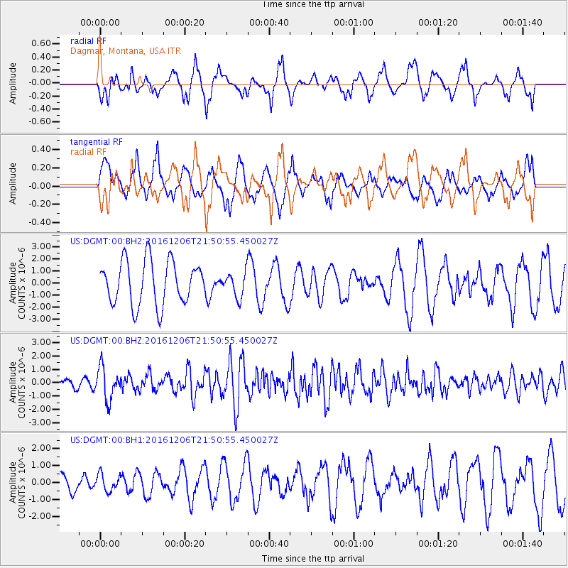
Signal To Noise
| Channel | StoN | STA | LTA |
| US:DGMT:00:BHZ:20161206T21:50:55.450027Z | 4.5337663 | 1.2286762E-6 | 2.7100563E-7 |
| US:DGMT:00:BH1:20161206T21:50:55.450027Z | 1.005365 | 5.080034E-7 | 5.0529246E-7 |
| US:DGMT:00:BH2:20161206T21:50:55.450027Z | 0.5755945 | 1.0456182E-6 | 1.8165881E-6 |
| Arrivals |
| Ps | |
| PpPs | |
| PsPs/PpSs | |


