You are here: Home > Network List > TA - USArray Transportable Network (new EarthScope stations) Stations List
> Station B23A Brockton, MT, USA > Earthquake Result Viewer
B23A Brockton, MT, USA - Earthquake Result Viewer
| Earthquake location: |
Near S. Coast Of Honshu, Japan |
| Earthquake latitude/longitude: |
33.2/137.9 |
| Earthquake time(UTC): |
2009/08/09 (221) 10:55:55 GMT |
| Earthquake Depth: |
297 km |
| Earthquake Magnitude: |
6.5 MB, 7.1 MW, 7.1 MW |
| Earthquake Catalog/Contributor: |
WHDF/NEIC |
|
| Network: |
TA USArray Transportable Network (new EarthScope stations) |
| Station: |
B23A Brockton, MT, USA |
| Lat/Lon: |
48.46 N/104.99 W |
| Elevation: |
716 m |
|
| Distance: |
81.2 deg |
| Az: |
36.847 deg |
| Baz: |
310.913 deg |
| Ray Param: |
0.046946175 |
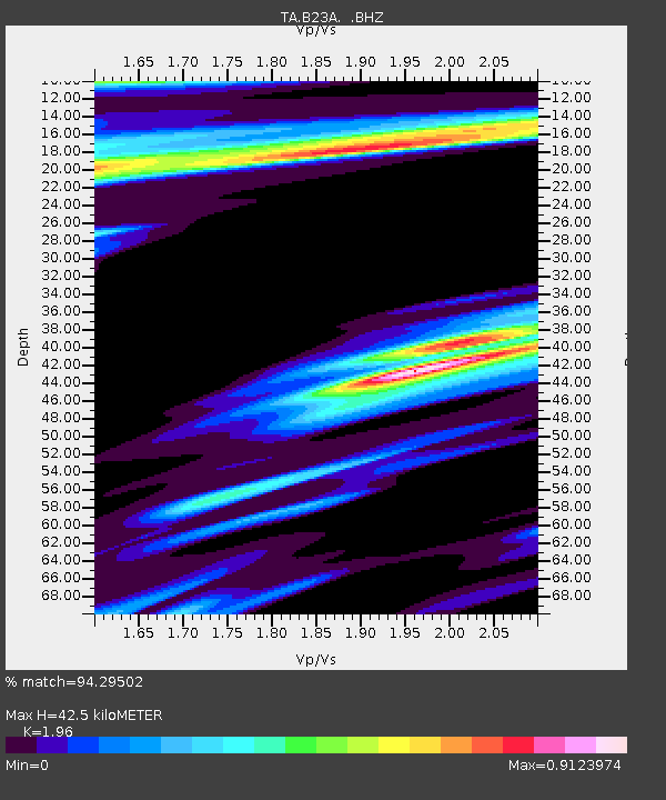
| Estimated Moho Depth: |
42.5 km |
| Estimated Crust Vp/Vs: |
1.96 |
| Assumed Crust Vp: |
6.438 km/s |
| Estimated Crust Vs: |
3.284 km/s |
| Estimated Crust Poisson's Ratio: |
0.32 |
|
| Radial Match: |
94.29502 % |
| Radial Bump: |
400 |
| Transverse Match: |
82.899605 % |
| Transverse Bump: |
400 |
| SOD ConfigId: |
2622 |
| Insert Time: |
2010-03-07 00:53:23.268 +0000 |
| GWidth: |
2.5 |
| Max Bumps: |
400 |
| Tol: |
0.001 |
|
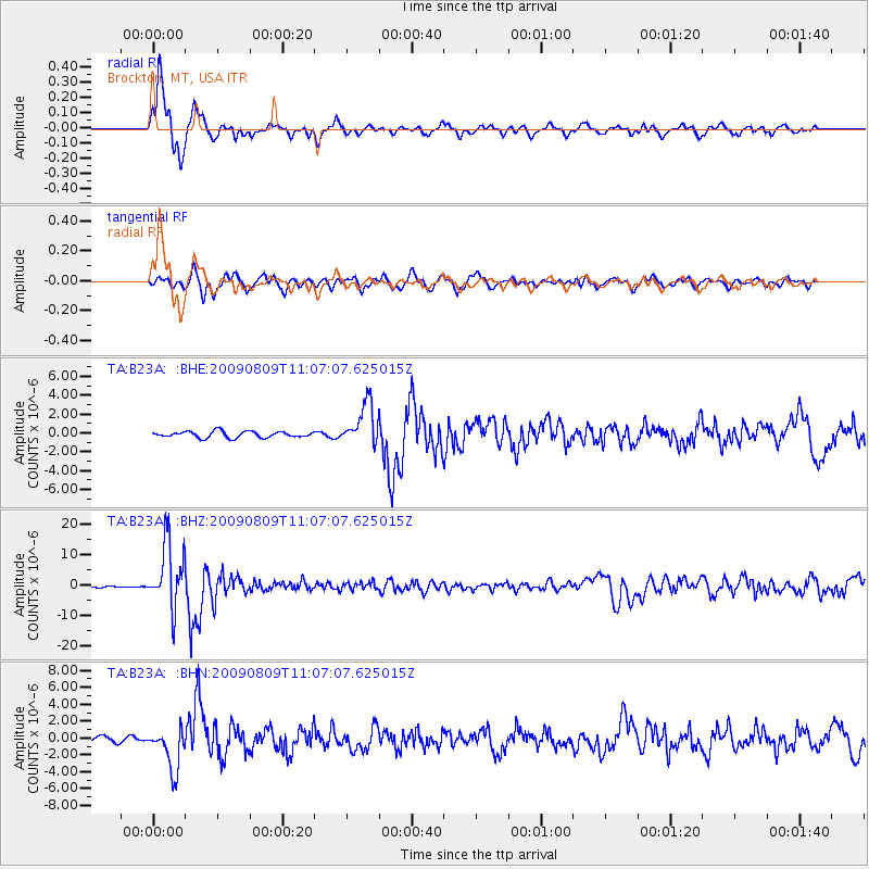
Signal To Noise
| Channel | StoN | STA | LTA |
| TA:B23A: :BHZ:20090809T11:07:07.625015Z | 66.749985 | 1.0593073E-5 | 1.5869774E-7 |
| TA:B23A: :BHN:20090809T11:07:07.625015Z | 7.4762416 | 2.5140944E-6 | 3.3627782E-7 |
| TA:B23A: :BHE:20090809T11:07:07.625015Z | 6.758708 | 2.2283834E-6 | 3.2970553E-7 |
| Arrivals |
| Ps | 6.5 SECOND |
| PpPs | 19 SECOND |
| PsPs/PpSs | 26 SECOND |


