You are here: Home > Network List > TA - USArray Transportable Network (new EarthScope stations) Stations List
> Station I27K Kandik River, AK, USA > Earthquake Result Viewer
I27K Kandik River, AK, USA - Earthquake Result Viewer
| Earthquake location: |
Mindanao, Philippines |
| Earthquake latitude/longitude: |
9.1/124.2 |
| Earthquake time(UTC): |
2019/07/01 (182) 16:59:25 GMT |
| Earthquake Depth: |
538 km |
| Earthquake Magnitude: |
5.9 Mww |
| Earthquake Catalog/Contributor: |
NEIC PDE/us |
|
| Network: |
TA USArray Transportable Network (new EarthScope stations) |
| Station: |
I27K Kandik River, AK, USA |
| Lat/Lon: |
65.60 N/141.62 W |
| Elevation: |
874 m |
|
| Distance: |
83.5 deg |
| Az: |
24.642 deg |
| Baz: |
277.577 deg |
| Ray Param: |
0.044602185 |
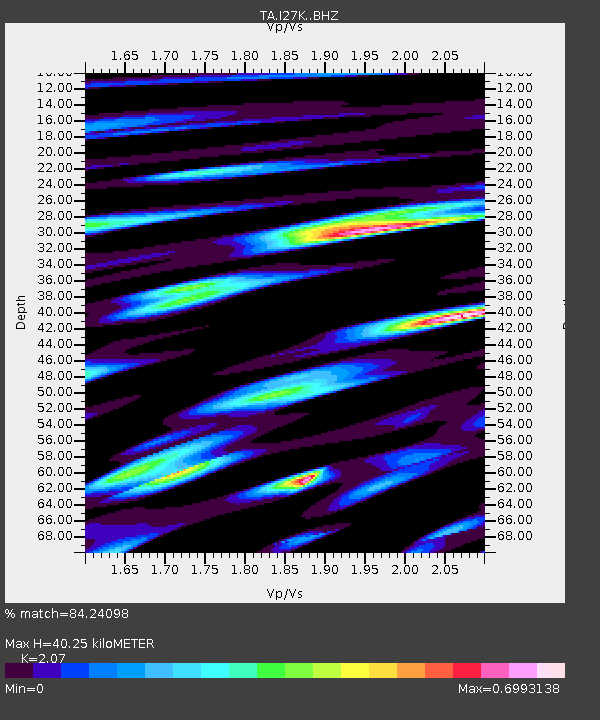
| Estimated Moho Depth: |
40.25 km |
| Estimated Crust Vp/Vs: |
2.07 |
| Assumed Crust Vp: |
6.566 km/s |
| Estimated Crust Vs: |
3.172 km/s |
| Estimated Crust Poisson's Ratio: |
0.35 |
|
| Radial Match: |
84.24098 % |
| Radial Bump: |
400 |
| Transverse Match: |
83.379326 % |
| Transverse Bump: |
400 |
| SOD ConfigId: |
18369291 |
| Insert Time: |
2019-07-15 17:05:23.056 +0000 |
| GWidth: |
2.5 |
| Max Bumps: |
400 |
| Tol: |
0.001 |
|

Signal To Noise
| Channel | StoN | STA | LTA |
| TA:I27K: :BHZ:20190701T17:10:25.624982Z | 25.395191 | 1.8269787E-6 | 7.194192E-8 |
| TA:I27K: :BHN:20190701T17:10:25.624982Z | 10.180109 | 4.1493928E-7 | 4.0759804E-8 |
| TA:I27K: :BHE:20190701T17:10:25.624982Z | 16.348877 | 7.7759836E-7 | 4.7562803E-8 |
| Arrivals |
| Ps | 6.7 SECOND |
| PpPs | 18 SECOND |
| PsPs/PpSs | 25 SECOND |


