You are here: Home > Network List > US - United States National Seismic Network Stations List
> Station MSO Missoula, Montana, USA > Earthquake Result Viewer
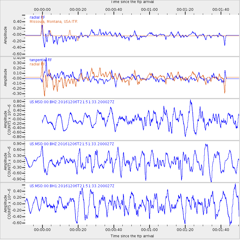
MSO Missoula, Montana, USA - Earthquake Result Viewer
*The percent match for this event was below the threshold and hence no stack was calculated.
| Earthquake location: |
Windward Islands |
| Earthquake latitude/longitude: |
11.1/-60.9 |
| Earthquake time(UTC): |
2016/12/06 (341) 21:42:21 GMT |
| Earthquake Depth: |
35 km |
| Earthquake Magnitude: |
5.9 Mww |
| Earthquake Catalog/Contributor: |
NEIC PDE/us |
|
| Network: |
US United States National Seismic Network |
| Station: |
MSO Missoula, Montana, USA |
| Lat/Lon: |
46.83 N/113.94 W |
| Elevation: |
1264 m |
|
| Distance: |
57.0 deg |
| Az: |
319.17 deg |
| Baz: |
110.814 deg |
| Ray Param: |
$rayparam |
*The percent match for this event was below the threshold and hence was not used in the summary stack. |
|
| Radial Match: |
46.130295 % |
| Radial Bump: |
400 |
| Transverse Match: |
59.684933 % |
| Transverse Bump: |
400 |
| SOD ConfigId: |
1894071 |
| Insert Time: |
2016-12-20 21:45:49.105 +0000 |
| GWidth: |
2.5 |
| Max Bumps: |
400 |
| Tol: |
0.001 |
|
Signal To Noise
| Channel | StoN | STA | LTA |
| US:MSO:00:BHZ:20161206T21:51:33.200027Z | 2.4649286 | 4.4157377E-7 | 1.7914263E-7 |
| US:MSO:00:BH1:20161206T21:51:33.200027Z | 0.7310746 | 1.2739757E-7 | 1.742607E-7 |
| US:MSO:00:BH2:20161206T21:51:33.200027Z | 1.2813983 | 2.8097622E-7 | 2.1927313E-7 |
| Arrivals |
| Ps | |
| PpPs | |
| PsPs/PpSs | |


