You are here: Home > Network List > TA - USArray Transportable Network (new EarthScope stations) Stations List
> Station B23A Brockton, MT, USA > Earthquake Result Viewer
B23A Brockton, MT, USA - Earthquake Result Viewer
| Earthquake location: |
Off Coast Of Ecuador |
| Earthquake latitude/longitude: |
1.4/-85.2 |
| Earthquake time(UTC): |
2009/05/10 (130) 01:16:06 GMT |
| Earthquake Depth: |
6.0 km |
| Earthquake Magnitude: |
5.5 MB, 5.7 MS, 6.1 MW, 6.1 MW |
| Earthquake Catalog/Contributor: |
WHDF/NEIC |
|
| Network: |
TA USArray Transportable Network (new EarthScope stations) |
| Station: |
B23A Brockton, MT, USA |
| Lat/Lon: |
48.46 N/104.99 W |
| Elevation: |
716 m |
|
| Distance: |
49.9 deg |
| Az: |
342.842 deg |
| Baz: |
153.697 deg |
| Ray Param: |
0.06840995 |
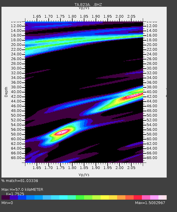
| Estimated Moho Depth: |
57.0 km |
| Estimated Crust Vp/Vs: |
1.75 |
| Assumed Crust Vp: |
6.438 km/s |
| Estimated Crust Vs: |
3.673 km/s |
| Estimated Crust Poisson's Ratio: |
0.26 |
|
| Radial Match: |
81.03336 % |
| Radial Bump: |
381 |
| Transverse Match: |
64.49223 % |
| Transverse Bump: |
399 |
| SOD ConfigId: |
2760 |
| Insert Time: |
2010-03-07 00:53:39.182 +0000 |
| GWidth: |
2.5 |
| Max Bumps: |
400 |
| Tol: |
0.001 |
|
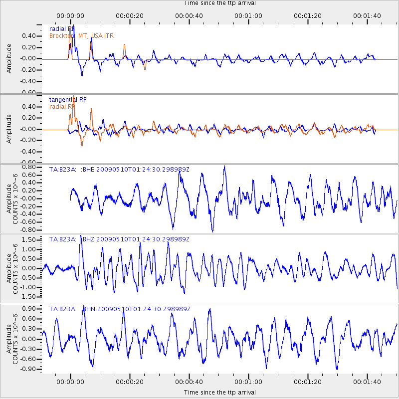
Signal To Noise
| Channel | StoN | STA | LTA |
| TA:B23A: :BHZ:20090510T01:24:30.298989Z | 5.522403 | 6.843815E-7 | 1.2392822E-7 |
| TA:B23A: :BHN:20090510T01:24:30.298989Z | 2.3643377 | 4.0172856E-7 | 1.6991166E-7 |
| TA:B23A: :BHE:20090510T01:24:30.298989Z | 1.8790945 | 3.3236688E-7 | 1.7687609E-7 |
| Arrivals |
| Ps | 7.1 SECOND |
| PpPs | 23 SECOND |
| PsPs/PpSs | 30 SECOND |


