You are here: Home > Network List > TA - USArray Transportable Network (new EarthScope stations) Stations List
> Station B23A Brockton, MT, USA > Earthquake Result Viewer
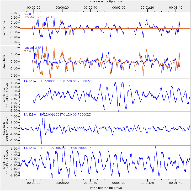
B23A Brockton, MT, USA - Earthquake Result Viewer
*The percent match for this event was below the threshold and hence no stack was calculated.
| Earthquake location: |
Tonga Islands |
| Earthquake latitude/longitude: |
-16.3/-173.5 |
| Earthquake time(UTC): |
2009/10/02 (275) 01:07:39 GMT |
| Earthquake Depth: |
8.0 km |
| Earthquake Magnitude: |
6.1 MB, 6.0 MS, 6.1 MW, 6.1 MW |
| Earthquake Catalog/Contributor: |
WHDF/NEIC |
|
| Network: |
TA USArray Transportable Network (new EarthScope stations) |
| Station: |
B23A Brockton, MT, USA |
| Lat/Lon: |
48.46 N/104.99 W |
| Elevation: |
716 m |
|
| Distance: |
88.5 deg |
| Az: |
38.271 deg |
| Baz: |
243.317 deg |
| Ray Param: |
$rayparam |
*The percent match for this event was below the threshold and hence was not used in the summary stack. |
|
| Radial Match: |
48.259434 % |
| Radial Bump: |
400 |
| Transverse Match: |
51.839745 % |
| Transverse Bump: |
382 |
| SOD ConfigId: |
2622 |
| Insert Time: |
2010-03-07 00:54:05.977 +0000 |
| GWidth: |
2.5 |
| Max Bumps: |
400 |
| Tol: |
0.001 |
|
Signal To Noise
| Channel | StoN | STA | LTA |
| TA:B23A: :BHZ:20091002T01:20:00.700002Z | 2.706648 | 6.637946E-7 | 2.4524599E-7 |
| TA:B23A: :BHN:20091002T01:20:00.700002Z | 1.1664871 | 3.4667656E-7 | 2.971971E-7 |
| TA:B23A: :BHE:20091002T01:20:00.700002Z | 1.193909 | 4.5971913E-7 | 3.8505374E-7 |
| Arrivals |
| Ps | |
| PpPs | |
| PsPs/PpSs | |


