You are here: Home > Network List > TA - USArray Transportable Network (new EarthScope stations) Stations List
> Station B23A Brockton, MT, USA > Earthquake Result Viewer
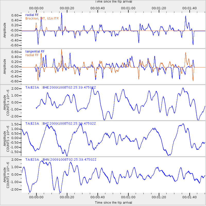
B23A Brockton, MT, USA - Earthquake Result Viewer
*The percent match for this event was below the threshold and hence no stack was calculated.
| Earthquake location: |
Santa Cruz Islands |
| Earthquake latitude/longitude: |
-11.7/166.2 |
| Earthquake time(UTC): |
2009/10/08 (281) 02:12:39 GMT |
| Earthquake Depth: |
35 km |
| Earthquake Magnitude: |
5.8 MB, 6.6 MW |
| Earthquake Catalog/Contributor: |
WHDF/NEIC |
|
| Network: |
TA USArray Transportable Network (new EarthScope stations) |
| Station: |
B23A Brockton, MT, USA |
| Lat/Lon: |
48.46 N/104.99 W |
| Elevation: |
716 m |
|
| Distance: |
97.8 deg |
| Az: |
42.201 deg |
| Baz: |
261.375 deg |
| Ray Param: |
$rayparam |
*The percent match for this event was below the threshold and hence was not used in the summary stack. |
|
| Radial Match: |
61.190617 % |
| Radial Bump: |
400 |
| Transverse Match: |
54.50674 % |
| Transverse Bump: |
400 |
| SOD ConfigId: |
2622 |
| Insert Time: |
2010-03-07 00:54:09.096 +0000 |
| GWidth: |
2.5 |
| Max Bumps: |
400 |
| Tol: |
0.001 |
|
Signal To Noise
| Channel | StoN | STA | LTA |
| TA:B23A: :BHZ:20091008T02:25:39.47502Z | 1.9335259 | 1.0578136E-6 | 5.4709045E-7 |
| TA:B23A: :BHN:20091008T02:25:39.47502Z | 1.1374322 | 1.4415391E-6 | 1.2673627E-6 |
| TA:B23A: :BHE:20091008T02:25:39.47502Z | 1.4265771 | 8.639702E-7 | 6.0562456E-7 |
| Arrivals |
| Ps | |
| PpPs | |
| PsPs/PpSs | |


