You are here: Home > Network List > TA - USArray Transportable Network (new EarthScope stations) Stations List
> Station B23A Brockton, MT, USA > Earthquake Result Viewer
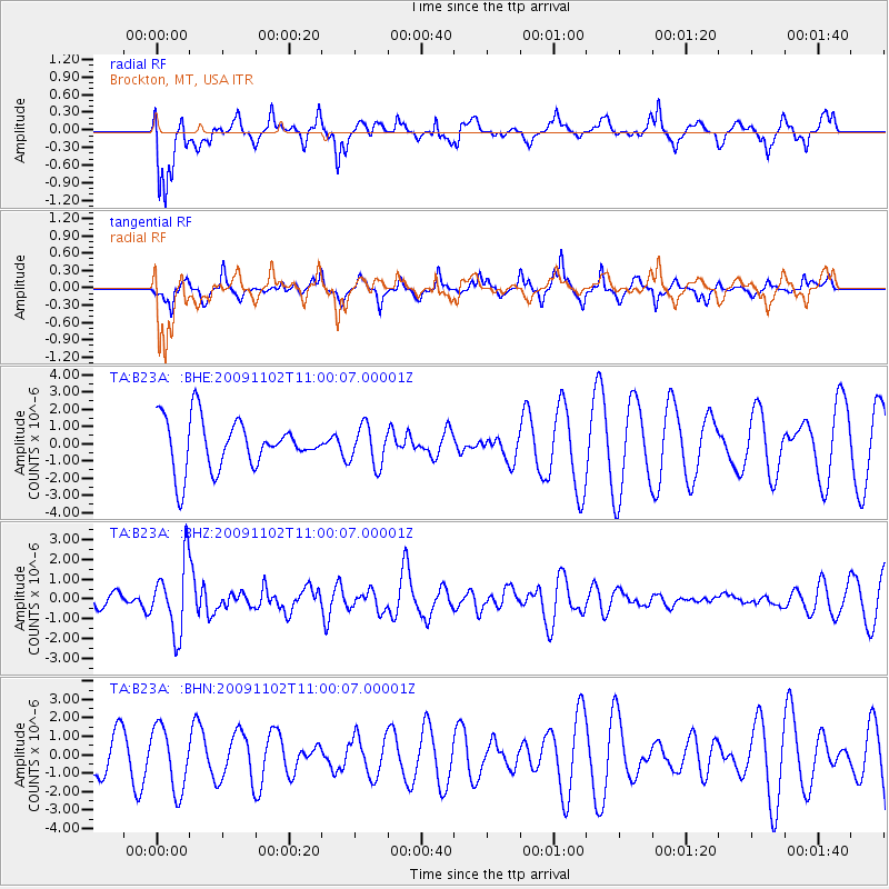
B23A Brockton, MT, USA - Earthquake Result Viewer
*The percent match for this event was below the threshold and hence no stack was calculated.
| Earthquake location: |
South Of Tonga Islands |
| Earthquake latitude/longitude: |
-24.1/-175.2 |
| Earthquake time(UTC): |
2009/11/02 (306) 10:47:13 GMT |
| Earthquake Depth: |
9.0 km |
| Earthquake Magnitude: |
6.1 MB, 6.1 MS, 6.2 MW, 6.1 MW |
| Earthquake Catalog/Contributor: |
WHDF/NEIC |
|
| Network: |
TA USArray Transportable Network (new EarthScope stations) |
| Station: |
B23A Brockton, MT, USA |
| Lat/Lon: |
48.46 N/104.99 W |
| Elevation: |
716 m |
|
| Distance: |
95.6 deg |
| Az: |
38.986 deg |
| Baz: |
239.731 deg |
| Ray Param: |
$rayparam |
*The percent match for this event was below the threshold and hence was not used in the summary stack. |
|
| Radial Match: |
62.212757 % |
| Radial Bump: |
400 |
| Transverse Match: |
62.586647 % |
| Transverse Bump: |
385 |
| SOD ConfigId: |
2622 |
| Insert Time: |
2010-03-07 00:54:14.229 +0000 |
| GWidth: |
2.5 |
| Max Bumps: |
400 |
| Tol: |
0.001 |
|
Signal To Noise
| Channel | StoN | STA | LTA |
| TA:B23A: :BHZ:20091102T11:00:07.00001Z | 3.3761196 | 1.767146E-6 | 5.2342523E-7 |
| TA:B23A: :BHN:20091102T11:00:07.00001Z | 1.0173 | 1.712328E-6 | 1.6832084E-6 |
| TA:B23A: :BHE:20091102T11:00:07.00001Z | 0.7941186 | 1.1393176E-6 | 1.4346947E-6 |
| Arrivals |
| Ps | |
| PpPs | |
| PsPs/PpSs | |


