You are here: Home > Network List > TA - USArray Transportable Network (new EarthScope stations) Stations List
> Station B23A Brockton, MT, USA > Earthquake Result Viewer
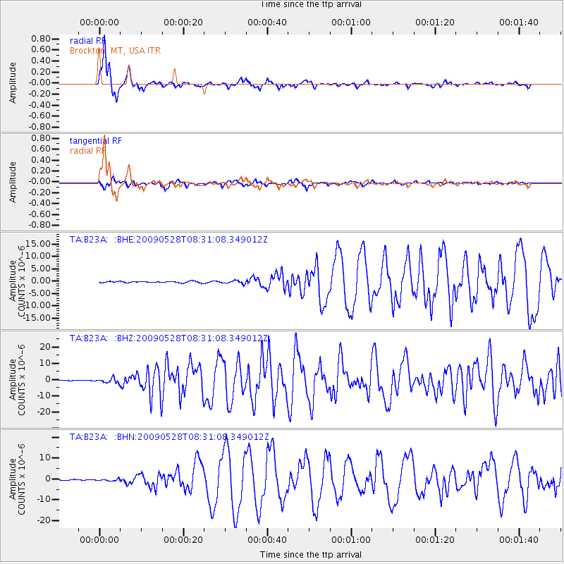
B23A Brockton, MT, USA - Earthquake Result Viewer
*The percent match for this event was below the threshold and hence no stack was calculated.
| Earthquake location: |
North Of Honduras |
| Earthquake latitude/longitude: |
16.7/-86.2 |
| Earthquake time(UTC): |
2009/05/28 (148) 08:24:45 GMT |
| Earthquake Depth: |
10 km |
| Earthquake Magnitude: |
6.7 MB, 7.2 MS, 7.3 MW, 7.3 MW |
| Earthquake Catalog/Contributor: |
WHDF/NEIC |
|
| Network: |
TA USArray Transportable Network (new EarthScope stations) |
| Station: |
B23A Brockton, MT, USA |
| Lat/Lon: |
48.46 N/104.99 W |
| Elevation: |
716 m |
|
| Distance: |
35.2 deg |
| Az: |
338.195 deg |
| Baz: |
147.67 deg |
| Ray Param: |
$rayparam |
*The percent match for this event was below the threshold and hence was not used in the summary stack. |
|
| Radial Match: |
95.01803 % |
| Radial Bump: |
290 |
| Transverse Match: |
81.22014 % |
| Transverse Bump: |
400 |
| SOD ConfigId: |
2648 |
| Insert Time: |
2010-03-07 00:54:15.794 +0000 |
| GWidth: |
2.5 |
| Max Bumps: |
400 |
| Tol: |
0.001 |
|
Signal To Noise
| Channel | StoN | STA | LTA |
| TA:B23A: :BHZ:20090528T08:31:08.349012Z | 11.270671 | 1.4736096E-6 | 1.307473E-7 |
| TA:B23A: :BHN:20090528T08:31:08.349012Z | 1.8469522 | 4.0163675E-7 | 2.174592E-7 |
| TA:B23A: :BHE:20090528T08:31:08.349012Z | 2.3259852 | 6.289028E-7 | 2.7038126E-7 |
| Arrivals |
| Ps | |
| PpPs | |
| PsPs/PpSs | |


