You are here: Home > Network List > TA - USArray Transportable Network (new EarthScope stations) Stations List
> Station B23A Brockton, MT, USA > Earthquake Result Viewer
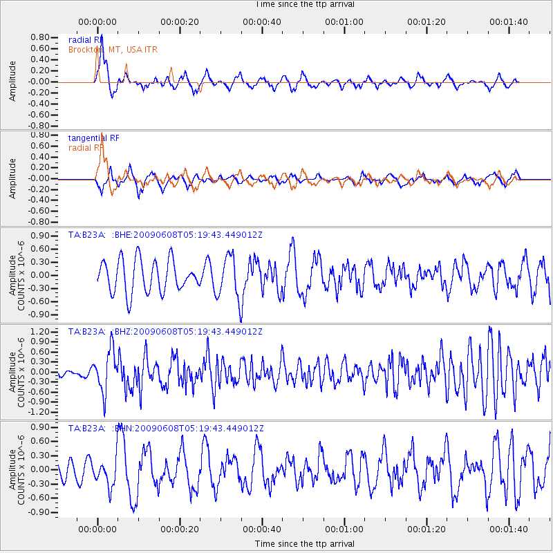
B23A Brockton, MT, USA - Earthquake Result Viewer
*The percent match for this event was below the threshold and hence no stack was calculated.
| Earthquake location: |
Honduras |
| Earthquake latitude/longitude: |
15.8/-86.9 |
| Earthquake time(UTC): |
2009/06/08 (159) 05:13:14 GMT |
| Earthquake Depth: |
10 km |
| Earthquake Magnitude: |
5.5 MB, 4.9 MS, 5.4 MW, 5.4 MW |
| Earthquake Catalog/Contributor: |
WHDF/NEIC |
|
| Network: |
TA USArray Transportable Network (new EarthScope stations) |
| Station: |
B23A Brockton, MT, USA |
| Lat/Lon: |
48.46 N/104.99 W |
| Elevation: |
716 m |
|
| Distance: |
35.8 deg |
| Az: |
339.281 deg |
| Baz: |
149.221 deg |
| Ray Param: |
$rayparam |
*The percent match for this event was below the threshold and hence was not used in the summary stack. |
|
| Radial Match: |
79.304405 % |
| Radial Bump: |
400 |
| Transverse Match: |
66.422806 % |
| Transverse Bump: |
352 |
| SOD ConfigId: |
2648 |
| Insert Time: |
2010-03-07 00:54:21.093 +0000 |
| GWidth: |
2.5 |
| Max Bumps: |
400 |
| Tol: |
0.001 |
|
Signal To Noise
| Channel | StoN | STA | LTA |
| TA:B23A: :BHZ:20090608T05:19:43.449012Z | 3.3615005 | 6.328841E-7 | 1.8827429E-7 |
| TA:B23A: :BHN:20090608T05:19:43.449012Z | 1.9674245 | 2.9756484E-7 | 1.5124589E-7 |
| TA:B23A: :BHE:20090608T05:19:43.449012Z | 1.3556256 | 4.944635E-7 | 3.6474927E-7 |
| Arrivals |
| Ps | |
| PpPs | |
| PsPs/PpSs | |


