You are here: Home > Network List > TA - USArray Transportable Network (new EarthScope stations) Stations List
> Station B23A Brockton, MT, USA > Earthquake Result Viewer
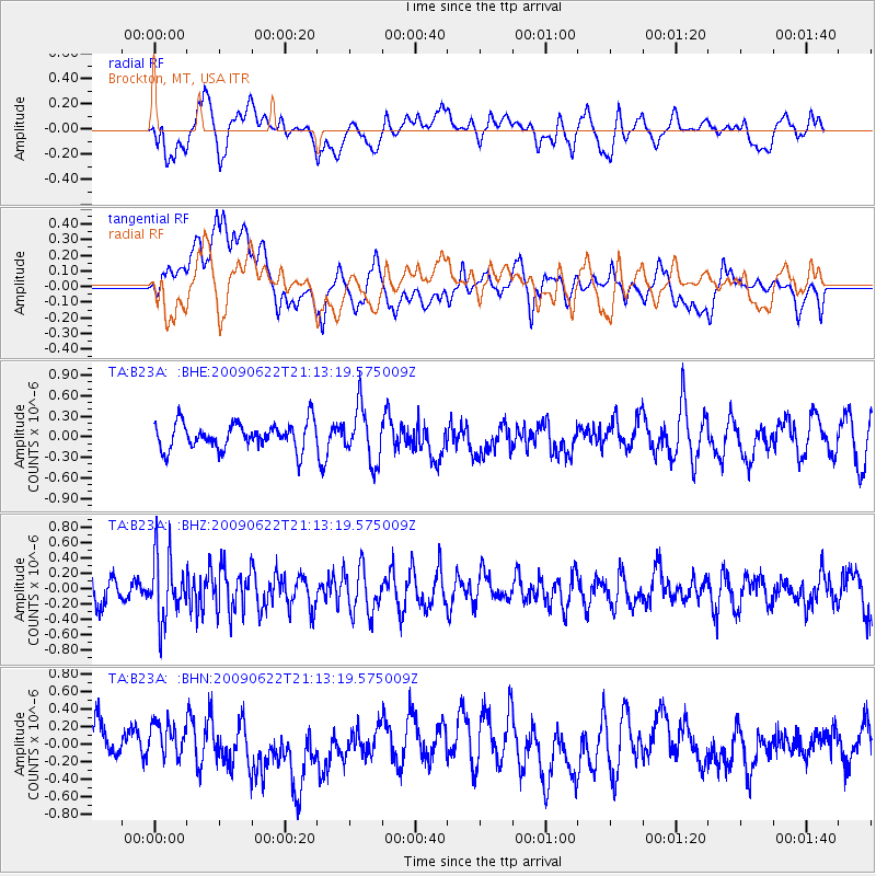
B23A Brockton, MT, USA - Earthquake Result Viewer
*The percent match for this event was below the threshold and hence no stack was calculated.
| Earthquake location: |
Andreanof Islands, Aleutian Is. |
| Earthquake latitude/longitude: |
51.3/-178.2 |
| Earthquake time(UTC): |
2009/06/22 (173) 21:05:33 GMT |
| Earthquake Depth: |
29 km |
| Earthquake Magnitude: |
5.5 MB, 5.0 MS, 5.4 MW, 5.4 MW |
| Earthquake Catalog/Contributor: |
WHDF/NEIC |
|
| Network: |
TA USArray Transportable Network (new EarthScope stations) |
| Station: |
B23A Brockton, MT, USA |
| Lat/Lon: |
48.46 N/104.99 W |
| Elevation: |
716 m |
|
| Distance: |
45.4 deg |
| Az: |
63.431 deg |
| Baz: |
302.564 deg |
| Ray Param: |
$rayparam |
*The percent match for this event was below the threshold and hence was not used in the summary stack. |
|
| Radial Match: |
46.394245 % |
| Radial Bump: |
400 |
| Transverse Match: |
41.70289 % |
| Transverse Bump: |
400 |
| SOD ConfigId: |
2648 |
| Insert Time: |
2010-03-07 00:54:28.584 +0000 |
| GWidth: |
2.5 |
| Max Bumps: |
400 |
| Tol: |
0.001 |
|
Signal To Noise
| Channel | StoN | STA | LTA |
| TA:B23A: :BHZ:20090622T21:13:19.575009Z | 2.764788 | 4.1771676E-7 | 1.5108455E-7 |
| TA:B23A: :BHN:20090622T21:13:19.575009Z | 0.8350078 | 1.8217226E-7 | 2.1816832E-7 |
| TA:B23A: :BHE:20090622T21:13:19.575009Z | 2.0497613 | 3.9231486E-7 | 1.9139539E-7 |
| Arrivals |
| Ps | |
| PpPs | |
| PsPs/PpSs | |


