You are here: Home > Network List > TA - USArray Transportable Network (new EarthScope stations) Stations List
> Station B23A Brockton, MT, USA > Earthquake Result Viewer
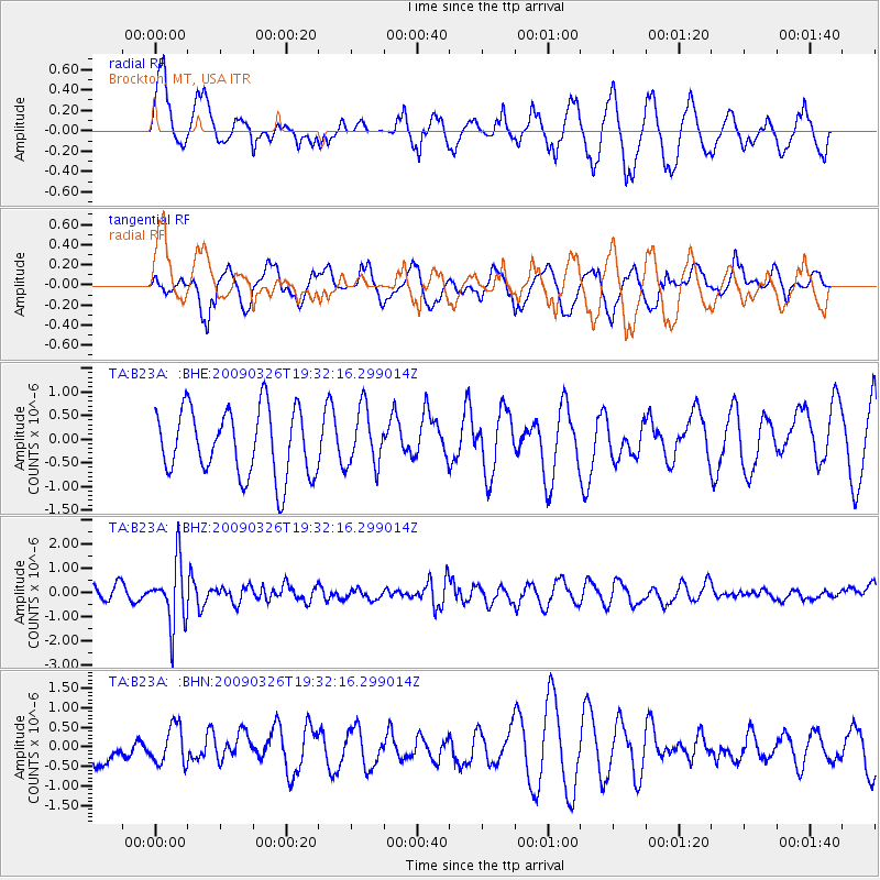
B23A Brockton, MT, USA - Earthquake Result Viewer
*The percent match for this event was below the threshold and hence no stack was calculated.
| Earthquake location: |
Northwest Of Ryukyu Islands |
| Earthquake latitude/longitude: |
27.4/126.7 |
| Earthquake time(UTC): |
2009/03/26 (085) 19:19:59 GMT |
| Earthquake Depth: |
160 km |
| Earthquake Magnitude: |
5.6 MB, 5.9 MW, 5.9 MW |
| Earthquake Catalog/Contributor: |
WHDF/NEIC |
|
| Network: |
TA USArray Transportable Network (new EarthScope stations) |
| Station: |
B23A Brockton, MT, USA |
| Lat/Lon: |
48.46 N/104.99 W |
| Elevation: |
716 m |
|
| Distance: |
91.4 deg |
| Az: |
31.496 deg |
| Baz: |
315.751 deg |
| Ray Param: |
$rayparam |
*The percent match for this event was below the threshold and hence was not used in the summary stack. |
|
| Radial Match: |
76.205635 % |
| Radial Bump: |
400 |
| Transverse Match: |
58.05626 % |
| Transverse Bump: |
400 |
| SOD ConfigId: |
2658 |
| Insert Time: |
2010-03-07 00:54:32.968 +0000 |
| GWidth: |
2.5 |
| Max Bumps: |
400 |
| Tol: |
0.001 |
|
Signal To Noise
| Channel | StoN | STA | LTA |
| TA:B23A: :BHZ:20090326T19:32:16.299014Z | 4.8752246 | 1.282328E-6 | 2.630295E-7 |
| TA:B23A: :BHN:20090326T19:32:16.299014Z | 1.0494642 | 4.890449E-7 | 4.6599482E-7 |
| TA:B23A: :BHE:20090326T19:32:16.299014Z | 0.8661135 | 6.114745E-7 | 7.0599816E-7 |
| Arrivals |
| Ps | |
| PpPs | |
| PsPs/PpSs | |


