You are here: Home > Network List > TA - USArray Transportable Network (new EarthScope stations) Stations List
> Station B23A Brockton, MT, USA > Earthquake Result Viewer
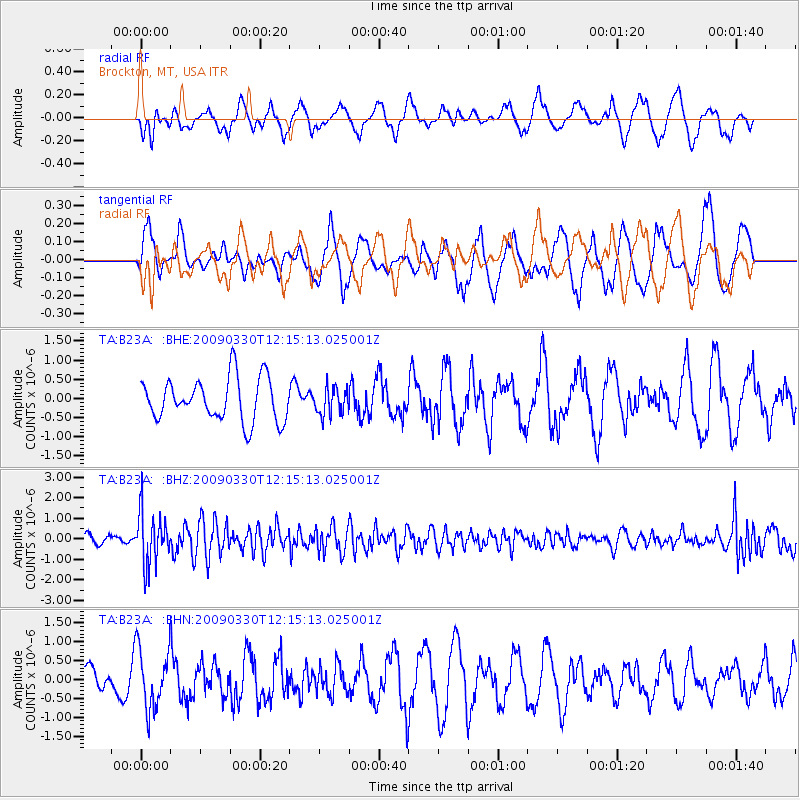
B23A Brockton, MT, USA - Earthquake Result Viewer
*The percent match for this event was below the threshold and hence no stack was calculated.
| Earthquake location: |
Andreanof Islands, Aleutian Is. |
| Earthquake latitude/longitude: |
51.5/-178.3 |
| Earthquake time(UTC): |
2009/03/30 (089) 12:07:28 GMT |
| Earthquake Depth: |
31 km |
| Earthquake Magnitude: |
6.0 MB, 5.5 MS, 5.7 MW, 5.7 MW |
| Earthquake Catalog/Contributor: |
WHDF/NEIC |
|
| Network: |
TA USArray Transportable Network (new EarthScope stations) |
| Station: |
B23A Brockton, MT, USA |
| Lat/Lon: |
48.46 N/104.99 W |
| Elevation: |
716 m |
|
| Distance: |
45.4 deg |
| Az: |
63.593 deg |
| Baz: |
302.806 deg |
| Ray Param: |
$rayparam |
*The percent match for this event was below the threshold and hence was not used in the summary stack. |
|
| Radial Match: |
55.412216 % |
| Radial Bump: |
400 |
| Transverse Match: |
45.20183 % |
| Transverse Bump: |
384 |
| SOD ConfigId: |
2658 |
| Insert Time: |
2010-03-07 00:54:35.131 +0000 |
| GWidth: |
2.5 |
| Max Bumps: |
400 |
| Tol: |
0.001 |
|
Signal To Noise
| Channel | StoN | STA | LTA |
| TA:B23A: :BHZ:20090330T12:15:13.025001Z | 4.0965567 | 1.2503705E-6 | 3.0522475E-7 |
| TA:B23A: :BHN:20090330T12:15:13.025001Z | 1.7226819 | 7.983626E-7 | 4.634417E-7 |
| TA:B23A: :BHE:20090330T12:15:13.025001Z | 0.62812406 | 3.5003094E-7 | 5.57264E-7 |
| Arrivals |
| Ps | |
| PpPs | |
| PsPs/PpSs | |


