You are here: Home > Network List > TA - USArray Transportable Network (new EarthScope stations) Stations List
> Station B23A Brockton, MT, USA > Earthquake Result Viewer
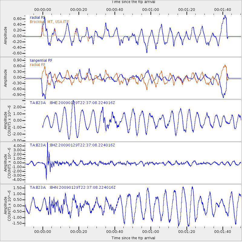
B23A Brockton, MT, USA - Earthquake Result Viewer
*The percent match for this event was below the threshold and hence no stack was calculated.
| Earthquake location: |
Western Brazil |
| Earthquake latitude/longitude: |
-8.1/-71.4 |
| Earthquake time(UTC): |
2009/01/29 (029) 22:28:05 GMT |
| Earthquake Depth: |
602 km |
| Earthquake Magnitude: |
5.7 MW, 5.3 MB, 5.6 MW |
| Earthquake Catalog/Contributor: |
WHDF/NEIC |
|
| Network: |
TA USArray Transportable Network (new EarthScope stations) |
| Station: |
B23A Brockton, MT, USA |
| Lat/Lon: |
48.46 N/104.99 W |
| Elevation: |
716 m |
|
| Distance: |
63.6 deg |
| Az: |
335.73 deg |
| Baz: |
142.304 deg |
| Ray Param: |
$rayparam |
*The percent match for this event was below the threshold and hence was not used in the summary stack. |
|
| Radial Match: |
55.111324 % |
| Radial Bump: |
400 |
| Transverse Match: |
57.889904 % |
| Transverse Bump: |
400 |
| SOD ConfigId: |
2658 |
| Insert Time: |
2010-03-07 00:54:35.791 +0000 |
| GWidth: |
2.5 |
| Max Bumps: |
400 |
| Tol: |
0.001 |
|
Signal To Noise
| Channel | StoN | STA | LTA |
| TA:B23A: :BHZ:20090129T22:37:08.224016Z | 6.410983 | 1.403353E-6 | 2.1889826E-7 |
| TA:B23A: :BHN:20090129T22:37:08.224016Z | 1.2317947 | 4.224644E-7 | 3.4296656E-7 |
| TA:B23A: :BHE:20090129T22:37:08.224016Z | 0.8602244 | 1.1616413E-6 | 1.3503934E-6 |
| Arrivals |
| Ps | |
| PpPs | |
| PsPs/PpSs | |


