You are here: Home > Network List > TA - USArray Transportable Network (new EarthScope stations) Stations List
> Station B23A Brockton, MT, USA > Earthquake Result Viewer
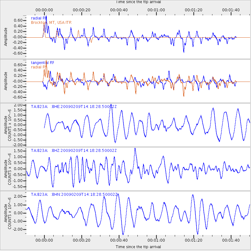
B23A Brockton, MT, USA - Earthquake Result Viewer
*The percent match for this event was below the threshold and hence no stack was calculated.
| Earthquake location: |
Near Coast Of Northern Peru |
| Earthquake latitude/longitude: |
-6.6/-81.2 |
| Earthquake time(UTC): |
2009/02/09 (040) 14:09:02 GMT |
| Earthquake Depth: |
15 km |
| Earthquake Magnitude: |
5.5 MB, 5.5 MS, 6.0 MW, 5.9 MW |
| Earthquake Catalog/Contributor: |
WHDF/NEIC |
|
| Network: |
TA USArray Transportable Network (new EarthScope stations) |
| Station: |
B23A Brockton, MT, USA |
| Lat/Lon: |
48.46 N/104.99 W |
| Elevation: |
716 m |
|
| Distance: |
58.7 deg |
| Az: |
341.641 deg |
| Baz: |
151.955 deg |
| Ray Param: |
$rayparam |
*The percent match for this event was below the threshold and hence was not used in the summary stack. |
|
| Radial Match: |
58.509556 % |
| Radial Bump: |
278 |
| Transverse Match: |
42.10721 % |
| Transverse Bump: |
272 |
| SOD ConfigId: |
2658 |
| Insert Time: |
2010-03-07 00:54:36.600 +0000 |
| GWidth: |
2.5 |
| Max Bumps: |
400 |
| Tol: |
0.001 |
|
Signal To Noise
| Channel | StoN | STA | LTA |
| TA:B23A: :BHZ:20090209T14:18:28.50002Z | 2.2726927 | 6.683708E-7 | 2.940876E-7 |
| TA:B23A: :BHN:20090209T14:18:28.50002Z | 1.0604248 | 6.7572984E-7 | 6.3722564E-7 |
| TA:B23A: :BHE:20090209T14:18:28.50002Z | 1.296998 | 7.1445606E-7 | 5.5085366E-7 |
| Arrivals |
| Ps | |
| PpPs | |
| PsPs/PpSs | |


