You are here: Home > Network List > TA - USArray Transportable Network (new EarthScope stations) Stations List
> Station B23A Brockton, MT, USA > Earthquake Result Viewer
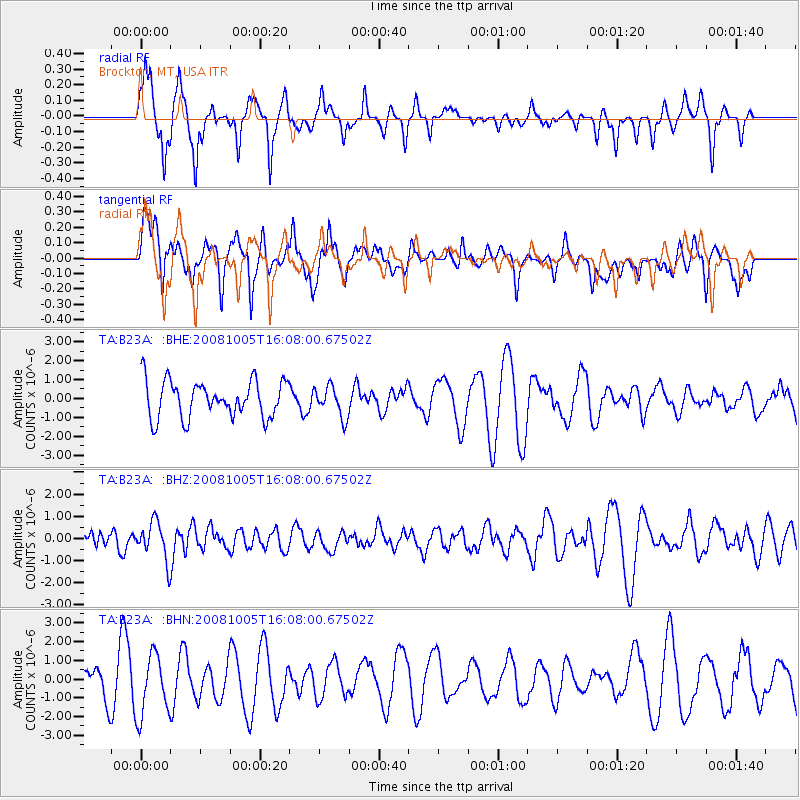
B23A Brockton, MT, USA - Earthquake Result Viewer
*The percent match for this event was below the threshold and hence no stack was calculated.
| Earthquake location: |
Tajikistan-Xinjiang Border Reg. |
| Earthquake latitude/longitude: |
39.4/73.7 |
| Earthquake time(UTC): |
2008/10/05 (279) 15:55:24 GMT |
| Earthquake Depth: |
35 km |
| Earthquake Magnitude: |
5.9 MB |
| Earthquake Catalog/Contributor: |
WHDF/NEIC |
|
| Network: |
TA USArray Transportable Network (new EarthScope stations) |
| Station: |
B23A Brockton, MT, USA |
| Lat/Lon: |
48.46 N/104.99 W |
| Elevation: |
716 m |
|
| Distance: |
92.5 deg |
| Az: |
359.103 deg |
| Baz: |
1.045 deg |
| Ray Param: |
$rayparam |
*The percent match for this event was below the threshold and hence was not used in the summary stack. |
|
| Radial Match: |
52.965435 % |
| Radial Bump: |
280 |
| Transverse Match: |
44.601757 % |
| Transverse Bump: |
400 |
| SOD ConfigId: |
2556 |
| Insert Time: |
2010-03-07 00:54:38.281 +0000 |
| GWidth: |
2.5 |
| Max Bumps: |
400 |
| Tol: |
0.001 |
|
Signal To Noise
| Channel | StoN | STA | LTA |
| TA:B23A: :BHZ:20081005T16:08:00.67502Z | 1.6286042 | 8.500212E-7 | 5.2193235E-7 |
| TA:B23A: :BHN:20081005T16:08:00.67502Z | 2.162941 | 1.6393607E-6 | 7.5793133E-7 |
| TA:B23A: :BHE:20081005T16:08:00.67502Z | 0.83920515 | 8.0810725E-7 | 9.629437E-7 |
| Arrivals |
| Ps | |
| PpPs | |
| PsPs/PpSs | |


