You are here: Home > Network List > TA - USArray Transportable Network (new EarthScope stations) Stations List
> Station B23A Brockton, MT, USA > Earthquake Result Viewer
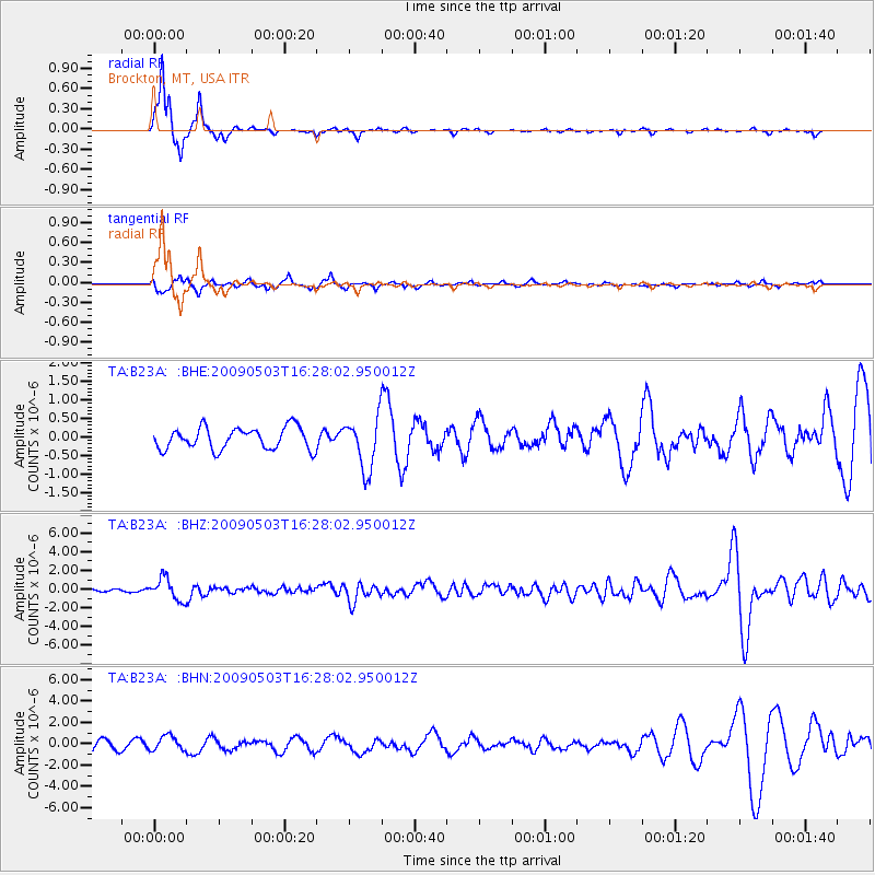
B23A Brockton, MT, USA - Earthquake Result Viewer
*The percent match for this event was below the threshold and hence no stack was calculated.
| Earthquake location: |
Guatemala |
| Earthquake latitude/longitude: |
14.6/-91.2 |
| Earthquake time(UTC): |
2009/05/03 (123) 16:21:47 GMT |
| Earthquake Depth: |
124 km |
| Earthquake Magnitude: |
5.6 MB, 6.2 MW, 6.2 MW |
| Earthquake Catalog/Contributor: |
WHDF/NEIC |
|
| Network: |
TA USArray Transportable Network (new EarthScope stations) |
| Station: |
B23A Brockton, MT, USA |
| Lat/Lon: |
48.46 N/104.99 W |
| Elevation: |
716 m |
|
| Distance: |
35.7 deg |
| Az: |
344.176 deg |
| Baz: |
156.63 deg |
| Ray Param: |
$rayparam |
*The percent match for this event was below the threshold and hence was not used in the summary stack. |
|
| Radial Match: |
91.94556 % |
| Radial Bump: |
218 |
| Transverse Match: |
64.080124 % |
| Transverse Bump: |
357 |
| SOD ConfigId: |
2658 |
| Insert Time: |
2010-03-07 00:54:40.116 +0000 |
| GWidth: |
2.5 |
| Max Bumps: |
400 |
| Tol: |
0.001 |
|
Signal To Noise
| Channel | StoN | STA | LTA |
| TA:B23A: :BHZ:20090503T16:28:02.950012Z | 10.002313 | 1.1705466E-6 | 1.170276E-7 |
| TA:B23A: :BHN:20090503T16:28:02.950012Z | 1.8414062 | 6.9717623E-7 | 3.7861076E-7 |
| TA:B23A: :BHE:20090503T16:28:02.950012Z | 2.3876364 | 7.0038624E-7 | 2.9333873E-7 |
| Arrivals |
| Ps | |
| PpPs | |
| PsPs/PpSs | |


