You are here: Home > Network List > TA - USArray Transportable Network (new EarthScope stations) Stations List
> Station B23A Brockton, MT, USA > Earthquake Result Viewer
B23A Brockton, MT, USA - Earthquake Result Viewer
*The percent match for this event was below the threshold and hence no stack was calculated.
| Earthquake location: |
Tonga Islands |
| Earthquake latitude/longitude: |
-17.3/-174.4 |
| Earthquake time(UTC): |
2008/11/05 (310) 03:41:43 GMT |
| Earthquake Depth: |
188 km |
| Earthquake Magnitude: |
5.7 MW, 5.1 MB, 5.7 MW |
| Earthquake Catalog/Contributor: |
WHDF/NEIC |
|
| Network: |
TA USArray Transportable Network (new EarthScope stations) |
| Station: |
B23A Brockton, MT, USA |
| Lat/Lon: |
48.46 N/104.99 W |
| Elevation: |
716 m |
|
| Distance: |
89.8 deg |
| Az: |
38.529 deg |
| Baz: |
243.377 deg |
| Ray Param: |
$rayparam |
*The percent match for this event was below the threshold and hence was not used in the summary stack. |
|
| Radial Match: |
80.72422 % |
| Radial Bump: |
400 |
| Transverse Match: |
54.588596 % |
| Transverse Bump: |
400 |
| SOD ConfigId: |
2658 |
| Insert Time: |
2010-03-07 00:54:41.800 +0000 |
| GWidth: |
2.5 |
| Max Bumps: |
400 |
| Tol: |
0.001 |
|
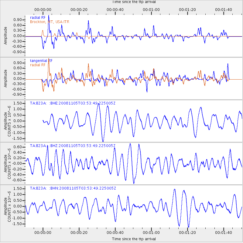
Signal To Noise
| Channel | StoN | STA | LTA |
| TA:B23A: :BHZ:20081105T03:53:49.225005Z | 1.342536 | 3.0420784E-7 | 2.2659196E-7 |
| TA:B23A: :BHN:20081105T03:53:49.225005Z | 0.42896068 | 2.3149317E-7 | 5.396606E-7 |
| TA:B23A: :BHE:20081105T03:53:49.225005Z | 2.7856498 | 1.0709853E-6 | 3.8446515E-7 |
| Arrivals |
| Ps | |
| PpPs | |
| PsPs/PpSs | |


