You are here: Home > Network List > TA - USArray Transportable Network (new EarthScope stations) Stations List
> Station B23A Brockton, MT, USA > Earthquake Result Viewer
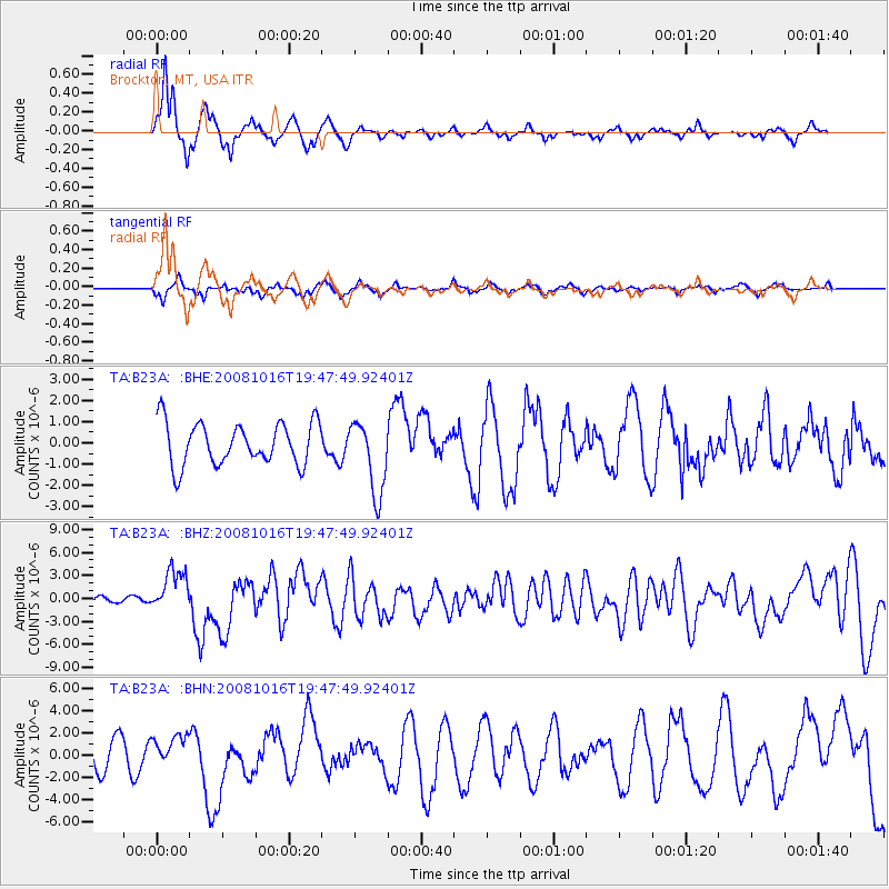
B23A Brockton, MT, USA - Earthquake Result Viewer
*The percent match for this event was below the threshold and hence no stack was calculated.
| Earthquake location: |
Near Coast Of Chiapas, Mexico |
| Earthquake latitude/longitude: |
14.4/-92.4 |
| Earthquake time(UTC): |
2008/10/16 (290) 19:41:25 GMT |
| Earthquake Depth: |
24 km |
| Earthquake Magnitude: |
6.1 MB, 6.6 MS, 6.7 MW, 6.6 MW |
| Earthquake Catalog/Contributor: |
WHDF/NEIC |
|
| Network: |
TA USArray Transportable Network (new EarthScope stations) |
| Station: |
B23A Brockton, MT, USA |
| Lat/Lon: |
48.46 N/104.99 W |
| Elevation: |
716 m |
|
| Distance: |
35.5 deg |
| Az: |
345.494 deg |
| Baz: |
158.615 deg |
| Ray Param: |
$rayparam |
*The percent match for this event was below the threshold and hence was not used in the summary stack. |
|
| Radial Match: |
84.33886 % |
| Radial Bump: |
315 |
| Transverse Match: |
43.75909 % |
| Transverse Bump: |
300 |
| SOD ConfigId: |
2556 |
| Insert Time: |
2010-03-07 00:54:43.663 +0000 |
| GWidth: |
2.5 |
| Max Bumps: |
400 |
| Tol: |
0.001 |
|
Signal To Noise
| Channel | StoN | STA | LTA |
| TA:B23A: :BHZ:20081016T19:47:49.92401Z | 8.6730585 | 2.769766E-6 | 3.193529E-7 |
| TA:B23A: :BHN:20081016T19:47:49.92401Z | 1.1229365 | 1.324771E-6 | 1.1797382E-6 |
| TA:B23A: :BHE:20081016T19:47:49.92401Z | 1.7397716 | 1.7260174E-6 | 9.920942E-7 |
| Arrivals |
| Ps | |
| PpPs | |
| PsPs/PpSs | |


