You are here: Home > Network List > TA - USArray Transportable Network (new EarthScope stations) Stations List
> Station B23A Brockton, MT, USA > Earthquake Result Viewer
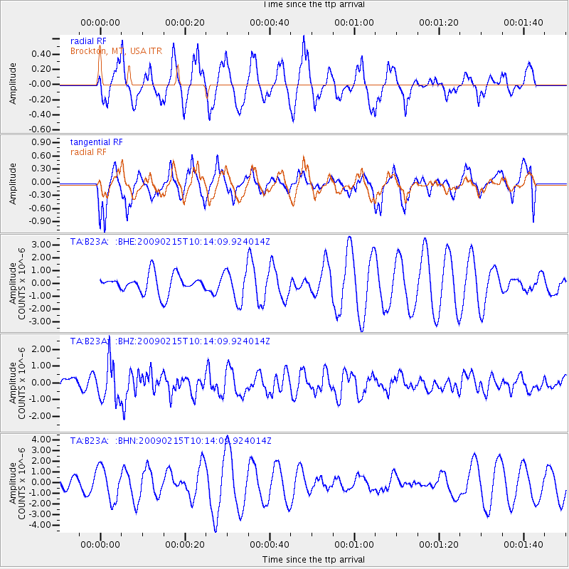
B23A Brockton, MT, USA - Earthquake Result Viewer
*The percent match for this event was below the threshold and hence no stack was calculated.
| Earthquake location: |
Near Coast Of Northern Peru |
| Earthquake latitude/longitude: |
-5.9/-80.9 |
| Earthquake time(UTC): |
2009/02/15 (046) 10:04:49 GMT |
| Earthquake Depth: |
21 km |
| Earthquake Magnitude: |
5.8 MB, 5.7 MS, 6.1 MW, 6.1 MW |
| Earthquake Catalog/Contributor: |
WHDF/NEIC |
|
| Network: |
TA USArray Transportable Network (new EarthScope stations) |
| Station: |
B23A Brockton, MT, USA |
| Lat/Lon: |
48.46 N/104.99 W |
| Elevation: |
716 m |
|
| Distance: |
58.1 deg |
| Az: |
341.324 deg |
| Baz: |
151.404 deg |
| Ray Param: |
$rayparam |
*The percent match for this event was below the threshold and hence was not used in the summary stack. |
|
| Radial Match: |
46.102303 % |
| Radial Bump: |
365 |
| Transverse Match: |
61.837635 % |
| Transverse Bump: |
390 |
| SOD ConfigId: |
2658 |
| Insert Time: |
2010-03-07 00:54:53.681 +0000 |
| GWidth: |
2.5 |
| Max Bumps: |
400 |
| Tol: |
0.001 |
|
Signal To Noise
| Channel | StoN | STA | LTA |
| TA:B23A: :BHZ:20090215T10:14:09.924014Z | 4.3039737 | 1.1557847E-6 | 2.6853897E-7 |
| TA:B23A: :BHN:20090215T10:14:09.924014Z | 1.2880002 | 1.5709832E-6 | 1.2197072E-6 |
| TA:B23A: :BHE:20090215T10:14:09.924014Z | 1.7462972 | 1.2752249E-6 | 7.3024506E-7 |
| Arrivals |
| Ps | |
| PpPs | |
| PsPs/PpSs | |


