You are here: Home > Network List > GO - National Seismic Network of Georgia Stations List
> Station ONI Oni > Earthquake Result Viewer
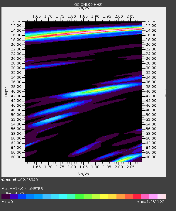
ONI Oni - Earthquake Result Viewer
| Earthquake location: |
Northern Sumatra, Indonesia |
| Earthquake latitude/longitude: |
5.3/96.1 |
| Earthquake time(UTC): |
2016/12/06 (341) 22:03:32 GMT |
| Earthquake Depth: |
8.2 km |
| Earthquake Magnitude: |
6.5 Mww |
| Earthquake Catalog/Contributor: |
NEIC PDE/us |
|
| Network: |
GO National Seismic Network of Georgia |
| Station: |
ONI Oni |
| Lat/Lon: |
42.59 N/43.45 E |
| Elevation: |
810 m |
|
| Distance: |
59.5 deg |
| Az: |
317.042 deg |
| Baz: |
113.23 deg |
| Ray Param: |
0.062160436 |
| Estimated Moho Depth: |
14.0 km |
| Estimated Crust Vp/Vs: |
1.93 |
| Assumed Crust Vp: |
6.247 km/s |
| Estimated Crust Vs: |
3.232 km/s |
| Estimated Crust Poisson's Ratio: |
0.32 |
|
| Radial Match: |
92.25949 % |
| Radial Bump: |
400 |
| Transverse Match: |
87.83376 % |
| Transverse Bump: |
400 |
| SOD ConfigId: |
1894071 |
| Insert Time: |
2016-12-20 22:04:27.722 +0000 |
| GWidth: |
2.5 |
| Max Bumps: |
400 |
| Tol: |
0.001 |
|

Signal To Noise
| Channel | StoN | STA | LTA |
| GO:ONI:00:HHZ:20161206T22:13:04.749998Z | 9.204486 | 5.4352756E-7 | 5.905029E-8 |
| GO:ONI:00:HHN:20161206T22:13:04.749998Z | 1.683289 | 1.3867226E-7 | 8.2381725E-8 |
| GO:ONI:00:HHE:20161206T22:13:04.749998Z | 1.6034709 | 2.2954505E-7 | 1.431551E-7 |
| Arrivals |
| Ps | 2.2 SECOND |
| PpPs | 6.3 SECOND |
| PsPs/PpSs | 8.5 SECOND |


