You are here: Home > Network List > TA - USArray Transportable Network (new EarthScope stations) Stations List
> Station A22A Carney Farms, Richland, MT, USA > Earthquake Result Viewer
A22A Carney Farms, Richland, MT, USA - Earthquake Result Viewer
| Earthquake location: |
Southeast Of Honshu, Japan |
| Earthquake latitude/longitude: |
32.8/140.4 |
| Earthquake time(UTC): |
2009/08/12 (224) 22:48:51 GMT |
| Earthquake Depth: |
53 km |
| Earthquake Magnitude: |
6.2 MB, 6.6 MW, 6.6 MW |
| Earthquake Catalog/Contributor: |
WHDF/NEIC |
|
| Network: |
TA USArray Transportable Network (new EarthScope stations) |
| Station: |
A22A Carney Farms, Richland, MT, USA |
| Lat/Lon: |
48.99 N/105.92 W |
| Elevation: |
861 m |
|
| Distance: |
79.5 deg |
| Az: |
37.845 deg |
| Baz: |
308.342 deg |
| Ray Param: |
0.048853867 |
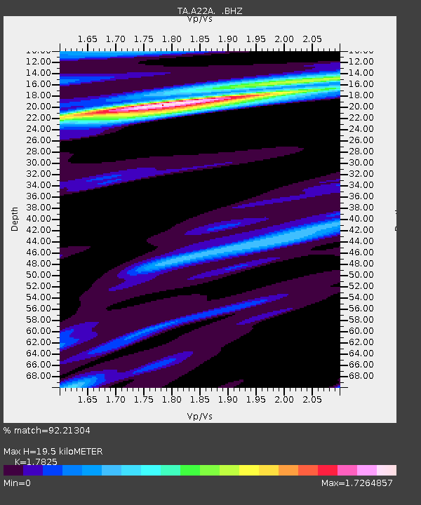
| Estimated Moho Depth: |
19.5 km |
| Estimated Crust Vp/Vs: |
1.78 |
| Assumed Crust Vp: |
6.438 km/s |
| Estimated Crust Vs: |
3.612 km/s |
| Estimated Crust Poisson's Ratio: |
0.27 |
|
| Radial Match: |
92.21304 % |
| Radial Bump: |
400 |
| Transverse Match: |
80.24067 % |
| Transverse Bump: |
400 |
| SOD ConfigId: |
2622 |
| Insert Time: |
2010-03-07 00:54:58.329 +0000 |
| GWidth: |
2.5 |
| Max Bumps: |
400 |
| Tol: |
0.001 |
|

Signal To Noise
| Channel | StoN | STA | LTA |
| TA:A22A: :BHZ:20090812T23:00:21.099016Z | 23.944305 | 3.214329E-6 | 1.3424189E-7 |
| TA:A22A: :BHN:20090812T23:00:21.099016Z | 4.8799033 | 7.486582E-7 | 1.534166E-7 |
| TA:A22A: :BHE:20090812T23:00:21.099016Z | 7.4214554 | 9.2568513E-7 | 1.2473095E-7 |
| Arrivals |
| Ps | 2.4 SECOND |
| PpPs | 8.2 SECOND |
| PsPs/PpSs | 11 SECOND |


