You are here: Home > Network List > TA - USArray Transportable Network (new EarthScope stations) Stations List
> Station A22A Carney Farms, Richland, MT, USA > Earthquake Result Viewer
A22A Carney Farms, Richland, MT, USA - Earthquake Result Viewer

| Earthquake location: |
Southern Peru |
| Earthquake latitude/longitude: |
-15.0/-70.4 |
| Earthquake time(UTC): |
2009/07/12 (193) 06:12:47 GMT |
| Earthquake Depth: |
199 km |
| Earthquake Magnitude: |
5.7 MB, 6.1 MW, 6.1 MW |
| Earthquake Catalog/Contributor: |
WHDF/NEIC |
|
| Network: |
TA USArray Transportable Network (new EarthScope stations) |
| Station: |
A22A Carney Farms, Richland, MT, USA |
| Lat/Lon: |
48.99 N/105.92 W |
| Elevation: |
861 m |
|
| Distance: |
71.1 deg |
| Az: |
336.169 deg |
| Baz: |
143.653 deg |
| Ray Param: |
0.054013133 |
| Estimated Moho Depth: |
18.75 km |
| Estimated Crust Vp/Vs: |
1.74 |
| Assumed Crust Vp: |
6.438 km/s |
| Estimated Crust Vs: |
3.7 km/s |
| Estimated Crust Poisson's Ratio: |
0.25 |
|
| Radial Match: |
89.96406 % |
| Radial Bump: |
400 |
| Transverse Match: |
71.29172 % |
| Transverse Bump: |
400 |
| SOD ConfigId: |
2648 |
| Insert Time: |
2010-03-07 00:55:05.564 +0000 |
| GWidth: |
2.5 |
| Max Bumps: |
400 |
| Tol: |
0.001 |
|
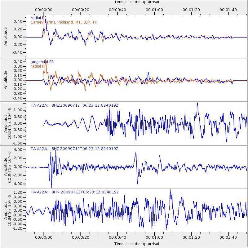
Signal To Noise
| Channel | StoN | STA | LTA |
| TA:A22A: :BHZ:20090712T06:23:12.824019Z | 16.719187 | 1.5543295E-6 | 9.2966815E-8 |
| TA:A22A: :BHN:20090712T06:23:12.824019Z | 1.5321362 | 2.418012E-7 | 1.5781966E-7 |
| TA:A22A: :BHE:20090712T06:23:12.824019Z | 1.5369154 | 2.96771E-7 | 1.9309519E-7 |
| Arrivals |
| Ps | 2.2 SECOND |
| PpPs | 7.7 SECOND |
| PsPs/PpSs | 9.9 SECOND |


