You are here: Home > Network List > IU - Global Seismograph Network (GSN - IRIS/USGS) Stations List
> Station CTAO Charters Towers, Australia > Earthquake Result Viewer
CTAO Charters Towers, Australia - Earthquake Result Viewer

| Earthquake location: |
Northern Sumatra, Indonesia |
| Earthquake latitude/longitude: |
5.3/96.1 |
| Earthquake time(UTC): |
2016/12/06 (341) 22:03:32 GMT |
| Earthquake Depth: |
8.2 km |
| Earthquake Magnitude: |
6.5 Mww |
| Earthquake Catalog/Contributor: |
NEIC PDE/us |
|
| Network: |
IU Global Seismograph Network (GSN - IRIS/USGS) |
| Station: |
CTAO Charters Towers, Australia |
| Lat/Lon: |
20.09 S/146.25 E |
| Elevation: |
357 m |
|
| Distance: |
55.3 deg |
| Az: |
118.702 deg |
| Baz: |
291.674 deg |
| Ray Param: |
0.064855196 |
| Estimated Moho Depth: |
39.0 km |
| Estimated Crust Vp/Vs: |
1.67 |
| Assumed Crust Vp: |
6.522 km/s |
| Estimated Crust Vs: |
3.911 km/s |
| Estimated Crust Poisson's Ratio: |
0.22 |
|
| Radial Match: |
95.43451 % |
| Radial Bump: |
274 |
| Transverse Match: |
88.23665 % |
| Transverse Bump: |
400 |
| SOD ConfigId: |
1894071 |
| Insert Time: |
2016-12-20 22:04:53.193 +0000 |
| GWidth: |
2.5 |
| Max Bumps: |
400 |
| Tol: |
0.001 |
|
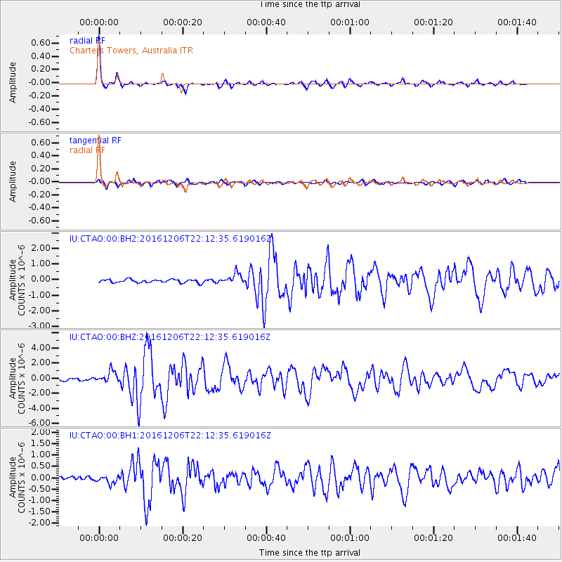
Signal To Noise
| Channel | StoN | STA | LTA |
| IU:CTAO:00:BHZ:20161206T22:12:35.619016Z | 7.555396 | 7.848658E-7 | 1.0388149E-7 |
| IU:CTAO:00:BH1:20161206T22:12:35.619016Z | 2.1348302 | 1.699305E-7 | 7.959907E-8 |
| IU:CTAO:00:BH2:20161206T22:12:35.619016Z | 3.4366944 | 3.5695905E-7 | 1.0386698E-7 |
| Arrivals |
| Ps | 4.2 SECOND |
| PpPs | 15 SECOND |
| PsPs/PpSs | 19 SECOND |


