You are here: Home > Network List > TA - USArray Transportable Network (new EarthScope stations) Stations List
> Station A22A Carney Farms, Richland, MT, USA > Earthquake Result Viewer
A22A Carney Farms, Richland, MT, USA - Earthquake Result Viewer
| Earthquake location: |
Guatemala |
| Earthquake latitude/longitude: |
14.6/-91.2 |
| Earthquake time(UTC): |
2009/05/03 (123) 16:21:47 GMT |
| Earthquake Depth: |
124 km |
| Earthquake Magnitude: |
5.6 MB, 6.2 MW, 6.2 MW |
| Earthquake Catalog/Contributor: |
WHDF/NEIC |
|
| Network: |
TA USArray Transportable Network (new EarthScope stations) |
| Station: |
A22A Carney Farms, Richland, MT, USA |
| Lat/Lon: |
48.99 N/105.92 W |
| Elevation: |
861 m |
|
| Distance: |
36.4 deg |
| Az: |
343.591 deg |
| Baz: |
155.463 deg |
| Ray Param: |
0.07628296 |
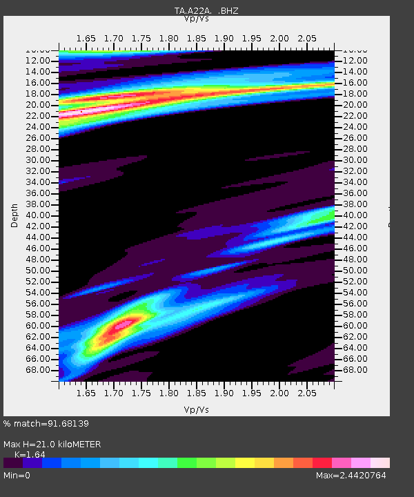
| Estimated Moho Depth: |
21.0 km |
| Estimated Crust Vp/Vs: |
1.64 |
| Assumed Crust Vp: |
6.438 km/s |
| Estimated Crust Vs: |
3.925 km/s |
| Estimated Crust Poisson's Ratio: |
0.20 |
|
| Radial Match: |
91.68139 % |
| Radial Bump: |
304 |
| Transverse Match: |
37.89762 % |
| Transverse Bump: |
378 |
| SOD ConfigId: |
2658 |
| Insert Time: |
2010-03-07 00:55:06.557 +0000 |
| GWidth: |
2.5 |
| Max Bumps: |
400 |
| Tol: |
0.001 |
|

Signal To Noise
| Channel | StoN | STA | LTA |
| TA:A22A: :BHZ:20090503T16:28:09.174011Z | 10.787464 | 1.1833446E-6 | 1.0969627E-7 |
| TA:A22A: :BHN:20090503T16:28:09.174011Z | 1.807237 | 9.50607E-7 | 5.260002E-7 |
| TA:A22A: :BHE:20090503T16:28:09.174011Z | 1.497324 | 4.2447954E-7 | 2.834921E-7 |
| Arrivals |
| Ps | 2.3 SECOND |
| PpPs | 7.9 SECOND |
| PsPs/PpSs | 10 SECOND |


